Filter: Categories of Wisconsin Historical Images
Filter: COLLECTION_NAME of Place File**
Filter: Year of 1800-1899
Filter: Community of Prairie du Chien
Filter: Categories of Wisconsin Historical Images
Filter: COLLECTION_NAME of Place File**
Filter: Year of 1800-1899
Filter: Community of Prairie du Chien
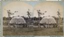
| Date: | 1872 |
|---|---|
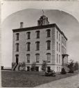
| Description: | Alleged to be the earliest known view of St. Mary's Institute, which later became St. Mary's College. One-half of a stereograph. |
| Date: | 1880 |
|---|---|
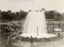
| Description: | Elevated view of Artesian Well, located near the intersection of Wisconsin Street and South Minnesota Street (since renamed Wacouta). It was dubbed by some... |
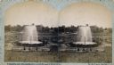
| Date: | 1880 |
|---|---|
| Description: | Stereograph of the Artesian Well near the intersection of Wisconsin and Minnesota (later renamed Wacouta) Streets. The following is printed on the back of ... |
| Date: | 1880 |
|---|---|
| Description: | Stereograph of the Artesian Well near the intersection of Wisconsin and Minnesota (later renamed Wacouta) Streets. The following is printed on the backside... |

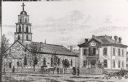
| Date: | 1836 |
|---|---|
| Description: | Woodcut of Prairie du Chien in 1836. Text at bottom reads: "Prairie du Chien in 1836. From an old cut." |
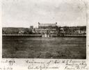
| Date: | 1860 |
|---|---|
| Description: | View from field of Villa Louis, the residence of Hercules L. Dousman. |
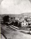
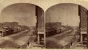
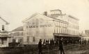
| Date: | 1870 |
|---|---|
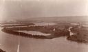
| Description: | One-half stereograph of town, elevated view looking northeast from Case's Block. |
| Date: | 1880 |
|---|---|
| Description: | Stereograph looking northeast from Case's Block. |
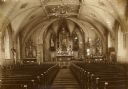
| Date: | 1890 |
|---|---|
| Description: | A view of the interior of St. Gabriel's Church. |
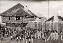
| Date: | 1887 |
|---|---|
| Description: | St. Gabriel's Roman Catholic Church. Horse-drawn vehicles and pedestrians are on the street and sidewalk in front of the church. |
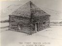
| Date: | 1840 |
|---|---|
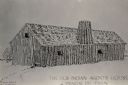
| Description: | The first school house at Prairie du Chien, Wisconsin. There is a fence behind the building, and hills in the background. |
| Date: | 1865 |
|---|---|
| Description: | Kane's Hotel, built in about 1839 by Ezekiel Tainter, and then called the Phoenix Hotel, on Main Street. It passed through many hands but retained the orig... |
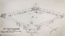
| Date: | 1814 |
|---|---|
| Description: | Fort Shelby built in 1814 and named for the Governor of Kentucky, was surrendered to British forces later in 1814 and renamed Fort McKay. Pictured here is ... |

| Date: | 1814 |
|---|---|
| Description: | Fort Shelby, built by the Americans during the War of 1812. In 1814 the fort surrendered to British forces led by Captain Andrew W. Bulger who renamed it F... |

| Date: | 1840 |
|---|---|
| Description: | Fort Crawford (the second site, with buildings of 1829-?), on the east bank of the Mississippi River, about 2 miles above the mouth of the Wisconsin River. |
| Date: | 1817 |
|---|---|
| Description: | Sketch of an elevated view of Fort Crawford (1816-1829). |
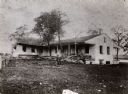
| Date: | 1880 |
|---|---|
| Description: | Fort Crawford Hospital. A man is sitting on a branch in the yard. |
If you didn't find the material you searched for, our Library Reference Staff can help.
Call our reference desk at 608-264-6535 or email us at: