 Filter: Categories of Wisconsin Historical Images
Filter: COLLECTION_NAME of Place File**
Filter: Year of 1800-1899
Filter: Type of Map or Atlas
Filter: Categories of Wisconsin Historical Images
Filter: COLLECTION_NAME of Place File**
Filter: Year of 1800-1899
Filter: Type of Map or Atlas
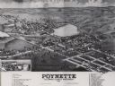
| Date: | 1882 |
|---|---|
| Description: | Bird's-eye map of Poynette, with one vignette. |

| Date: | 1861 |
|---|---|
| Description: | Bird's-eye map of Fond du Lac, "drawn after nature," with a parade of soldiers marching down the street. |

| Date: | 1875 |
|---|---|
| Description: | Bird's-eye map after a fire destroyed a large area of the town. In memory of the Great Conflagration on April 28th, 1875. Taken from the North-Side. |

| Date: | 1893 |
|---|---|
| Description: | Bird's-eye map of Sturgeon Bay, looking Northeast. Area bordered by Church Street in top left corner, leather & Smith Bridge in bottom left corner, Lawrenc... |

| Date: | 1880 |
|---|---|
| Description: | Bird's-eye map of Sturgeon Bay. County Seat of Door County. |

| Date: | 02 26 1887 |
|---|---|
| Description: | Bird's-eye map of Ashland, and the Apostle Islands in Lake Superior. Caption reads: "Ashland and the Apostle Islands." |

| Date: | 1890 |
|---|---|
| Description: | Bird's-eye view of Sheboygan on an advertisement for Kempf's Magical Salve, distributed by E.J. Kempf, "Legitimate Bill Poster and Distributor." |

| Date: | 1867 |
|---|---|
| Description: | Drawn map showing planned development of Cornell, including a couple of schools, Oakwood cemetery, the public square, and several bridges and dams. |

| Date: | 1889 |
|---|---|
| Description: | Dane County Courthouse, begun in the fall of 1883 and finished in the spring of 1886. The cost, including equipment, was a little over $180,000. |

| Date: | 1836 |
|---|---|
| Description: | The map of Wisconsin City on the Wisconsin River. |

| Date: | 1859 |
|---|---|
| Description: | Map featuring various views of buildings and scenes from Sauk County. |

| Date: | 1821 |
|---|---|
| Description: | A topographical view of the site of Fort Crawford. |

| Date: | 1833 |
|---|---|
| Description: | Published in James Smith Buck's, "Pioneer History of Milwaukee". Lake Michigan is on the right, with three rivers that combine at different points and reac... |

| Date: | 1833 |
|---|---|
| Description: | Drawing on a faint grid with Lake Michigan on the right, and the rivers on the left. Labeled is an Indian Village, J. Veiu, S. Juneau, and P. Juneau. Alo... |

| Date: | 1886 |
|---|---|
| Description: | Detail of map including plans of the National Soldiers' home. |

| Date: | 1876 |
|---|---|
| Description: | Map of home and land, with the roads, lakes, railroad, and buildings. |
If you didn't find the material you searched for, our Library Reference Staff can help.
Call our reference desk at 608-264-6535 or email us at:


