Filter: Categories of Wisconsin Historical Images
Filter: COLLECTION_NAME of Place File**
Filter: Subject of transportation
Filter: Creator Name of Newhouse, John
Filter: Categories of Wisconsin Historical Images
Filter: COLLECTION_NAME of Place File**
Filter: Subject of transportation
Filter: Creator Name of Newhouse, John
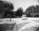
| Date: | 1955 |
|---|---|
| Description: | Nakoma, showing a Nakoma bus when the route first started. |
| Date: | 1948 |
|---|---|
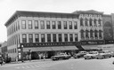
| Description: | Exterior view from street of O.N. Falk's Drug Store, on Main Street. |
| Date: | 1954 |
|---|---|
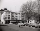
| Description: | View of the corner of Carroll and West Main Streets downtown. The Park Hotel occupies the large building. The Prescription Pharmacy, the Park Hotel Barber ... |
| Date: | 1955 |
|---|---|
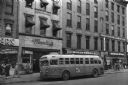
| Description: | Bus traveling down Mifflin Street on Capitol Square. Moseleys, Woldenbergs and Walgreen's Drugs are on the right. |

| Date: | 1956 |
|---|---|
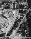
| Description: | Aerial view of lower University of Wisconsin-Madison campus with demolition of buildings on both sides of the Armory-Gymnasium to make space for future pla... |
| Date: | 1954 |
|---|---|
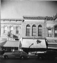
| Description: | S.S. Kresge storefront and Miller's clothing store on Main Street. |

| Date: | 1945 |
|---|---|
| Description: | Aerial view of the "powder storage area" of the Badger Ordnance Plant. |

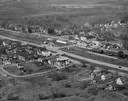
| Date: | 1955 |
|---|---|
| Description: | Aerial view of Cross Plains, with countryside surrounding and hills on the horizon. |

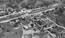
| Date: | 1950 |
|---|---|
| Description: | Aerial view of main street. There is a bridge with a stream flowing under it in the foreground. |
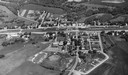
| Date: | 1950 |
|---|---|
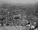
| Description: | Aerial view of the main street of town. |
| Date: | 1957 |
|---|---|
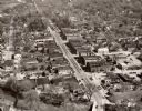
| Description: | Aerial view of downtown with surrounding landscape. |
| Date: | 1957 |
|---|---|
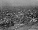
| Description: | Aerial view of town and the surrounding countryside. |
| Date: | 1954 |
|---|---|
| Description: | An air view of Madison including the Veterans Hospital, Forest Products Laboratory and University Avenue from Farley (lower edge), to Allen Streets. |

| Date: | 1956 |
|---|---|
| Description: | Aerial view looking northeast from a point over the east end of Middleton, showing the west end of Lake Mendota (right mid-ground). Fox Bluff juts into the... |

| Date: | 1956 |
|---|---|
| Description: | Aerial view, looking eastward from a point several miles outside the southwestern limits of Madison in the direction of Verona. Crossing the image diagonal... |
If you didn't find the material you searched for, our Library Reference Staff can help.
Call our reference desk at 608-264-6535 or email us at: