Filter: Categories of Wisconsin Historical Images
Filter: COLLECTION_NAME of Place File*
Filter: Creator Name of Unknown
Filter: Subject of fields (agriculture)
Filter: Categories of Wisconsin Historical Images
Filter: COLLECTION_NAME of Place File*
Filter: Creator Name of Unknown
Filter: Subject of fields (agriculture)

| Date: | 1862 |
|---|---|
| Description: | Camp Randall looking southwest. In April 1861, Governor Alexander Randall asked that the State Agricultural Society fairgrounds be converted into a militar... |

| Date: | 1908 |
|---|---|
| Description: | Aerial view of Camp Randall Field on the University of Wisconsin-Madison campus. University Heights is in the background. |
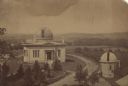
| Date: | 1880 |
|---|---|
| Description: | Elevated view of the University of Wisconsin-Madison Washburn Observatory. Hill, trees and fields are in the background. A man is standing near a small obs... |
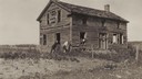
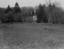
| Date: | 1920 |
|---|---|
| Description: | View of an old home or inn. Two people are looking out of an open window, and two men are standing outside leaning against the building. |

| Date: | 1965 |
|---|---|
| Description: | Aerial view of downtown Big Falls and the Little Wolf River. The Little Wolf River is at lower right. |

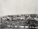
| Date: | 1905 |
|---|---|
| Description: | Aerial view of town, with several large buildings along railroad tracks in the foreground, and fields and trees in the distance. Pedestrians are walking al... |
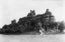
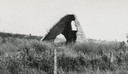
| Date: | 1937 |
|---|---|
| Description: | Castle Rock. Castle Rock is an example of a monadnock or inselberg, a geological formation common in northern and central Wisconsin. |
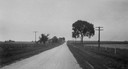
| Date: | 07 15 1925 |
|---|---|
| Description: | Natesta cabin site in Clinton. View down road, with a fence on the right, and fields on both sides. |
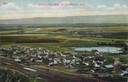
| Date: | |
|---|---|
| Description: | Elevated view of Cochrane and the surrounding landscape. There are houses, railroad tracks, distant fields, a pond and some irrigation canals. Caption read... |
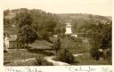
| Date: | 1900 |
|---|---|
| Description: | Elevated view of wagon bridge in Darlington, with a river on the right, a cow in a field, and a building on the left. |

| Date: | 1910 |
|---|---|
| Description: | Elevated view of the Pecatonica River, which is curving from left to right, making two hairpin turns among fields and trees. Hills are in the distance. |
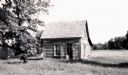
| Date: | 1955 |
|---|---|
| Description: | Small log house near Edgewood School in Deer Park. |

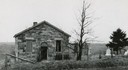
| Date: | 1884 |
|---|---|
| Description: | View of buildings in Delafield, with two men and a dog standing near a fence in the foreground. |
| Date: | 1920 |
|---|---|
| Description: | Charcoal kiln in an overgrown field. Producing charcoal was once a fairly large industry in De Pere. |
| Date: | 1920 |
|---|---|
| Description: | Charcoal kiln in ruins in a field beyond a fence, with electric power lines in the background. |
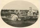
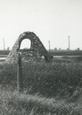
| Date: | 1947 |
|---|---|
| Description: | Laxey Church, built prior to the Civil War, was named after Laxey in the Isle of Man, from which many of the immigrants had come. There is a cemetery with ... |
| Date: | |
|---|---|
| Description: | Rock Studio across a field, surrounded by trees. |
If you didn't find the material you searched for, our Library Reference Staff can help.
Call our reference desk at 608-264-6535 or email us at: