Filter: Categories of Wisconsin Historical Images
Filter: COLLECTION_NAME of Place File
Filter: County of Winnebago
Filter: Subject of transportation
Filter: Categories of Wisconsin Historical Images
Filter: COLLECTION_NAME of Place File
Filter: County of Winnebago
Filter: Subject of transportation

| Date: | 1875 |
|---|---|
| Description: | Bird's-eye map after a fire destroyed a large area of the town. In memory of the Great Conflagration on April 28th, 1875. Taken from the North-Side. |
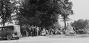
| Date: | 1930 |
|---|---|
| Description: | View of crowd of people under the trees near the trading post marker in Butte des Morts. |

| Date: | 1879 |
|---|---|
| Description: | The Reliance Flooring Mill. Men are posing in front, and another man is on a horse-drawn vehicle near the loading dock. The mill building was physically mo... |

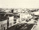
| Date: | 1875 |
|---|---|
| Description: | View down unpaved street in Winneconne towards the bridge from the east side of town. Storefronts on the left have signs for "Stoves & Tinware" and "Harnes... |
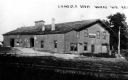
| Date: | 1920 |
|---|---|
| Description: | View of the Chicago, Milwaukee, and St. Paul railroad depot. Caption reads: "C. M. and St. P. Depot, Waukau Wis." |
| Date: | 1909 |
|---|---|
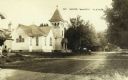
| Description: | Street scene featuring a Methodist church. In front of the church a young boy stands in the dirt road near a man sitting in a horse-drawn wagon with a dog.... |

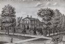
| Date: | 1870 |
|---|---|
| Description: | Elevated view of City Square, where the Bank of Menasha is seen on the corner and Little Lake Butte des Mortes is in the distance. |
| Date: | 1871 |
|---|---|
| Description: | Stereograph of the Congregational Church on the corner of Broad and Milwaukee Streets. |
| Date: | 1905 |
|---|---|
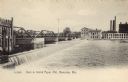
| Description: | The Island Paper Mill and dam in Menasha. Caption reads: "Dam & Island Paper Mill, Menasha, Wis." |
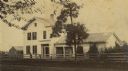
| Date: | |
|---|---|
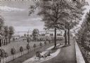
| Description: | A drawing from Harney's "History of Winnebago County" of E.L. Mathewson's home on Doty Island. |
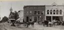
| Date: | 1871 |
|---|---|
| Description: | Stereograph of the town square and Main Street. The three-story building in the center was operated as the National Hotel. It was later burned down and was... |
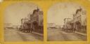
| Date: | 1870 |
|---|---|
| Description: | Elevated view of Main Street looking east toward the Fox River and the boat landing. Lake Winnebago is in the distance. |

| Date: | 1870 |
|---|---|
| Description: | The corner of unpaved Main Street and Tayco Street looking south towards Doty Island. The slanting timbers controlled the primitive draw bridge across the ... |

| Date: | 1870 |
|---|---|
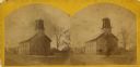
| Description: | The National Hotel on town square off of Main Street. A group of people and horse-drawn vehicles are in front of the hotel. |
| Date: | |
|---|---|
| Description: | Looking west on to Public Square. There are horse-drawn vehicles and a streetcar in the foreground. |

| Date: | 08 24 1888 |
|---|---|
| Description: | The George A. Whiting Paper Mill after a fire on August 24, 1888. Sixteen men were killed by the explosion of a bleacher; the bleacher exploded as the nigh... |
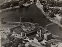
| Date: | 1949 |
|---|---|
| Description: | Aerial view of the George A. Whiting Paper Mill. |
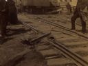
| Date: | 08 24 1888 |
|---|---|
| Description: | The George A. Whiting Paper Mill after a fire on August 24, 1888. Men and women are standing near the damaged railroad tracks. Sixteen men were killed by t... |
If you didn't find the material you searched for, our Library Reference Staff can help.
Call our reference desk at 608-264-6535 or email us at: