Filter: Categories of Wisconsin Historical Images
Filter: COLLECTION_NAME of Map Collection
Filter: Year of 1800-1899
Filter: Year of 1870-1879
Filter: Categories of Wisconsin Historical Images
Filter: COLLECTION_NAME of Map Collection
Filter: Year of 1800-1899
Filter: Year of 1870-1879

| Date: | 1878 |
|---|---|
| Description: | A color map detailing Ashland and Bayfield counties, including Lake Superior and the Apostle Islands. |

| Date: | 1878 |
|---|---|
| Description: | Illustrated map of Crawford County. On the bottom right is an inset of a group of people near a train on a railroad track. |
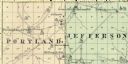
| Date: | 1878 |
|---|---|
| Description: | A map of Portland and Jefferson in Monroe County. |
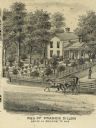
| Date: | 1873 |
|---|---|
| Description: | Engraved view of the home of Francis Dillon. A woman rides on the road in front of the home in a horse-drawn carriage. A woman stands on the porch of the h... |

| Date: | 1877 |
|---|---|
| Description: | Map of northern Wisconsin showing the lands owned by Cornell University (shaded portions) in 1877. The map depicts the lakes, river systems, towns, and th... |

| Date: | 1878 |
|---|---|
| Description: | This map shows block numbers, wards, roads, railroads, parks, and selected buildings and includes a "Milwaukee city street guide" as well as a guide to pub... |

| Date: | 1876 |
|---|---|
| Description: | Detailed topographic map of the Gettysburg battlefield created thirteen years after the battle. This map shows day one of the battle. The map shows drainag... |

| Date: | 1876 |
|---|---|
| Description: | This map of the Battle of Iuka depicts the May 19, 1862, positions of the Union forces in blue and Confederate in red. Indicated on the map are roads, the ... |
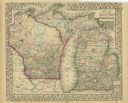
| Date: | 1870 |
|---|---|
| Description: | A hand-colored map of Wisconsin and Michigan detailing the states’ rivers, lakes, counties, town and cities. The map gives the greatest length, breadth, me... |

| Date: | 1870 |
|---|---|
| Description: | A geological survey map of Wisconsin, with hand-colored portions showing the surveys completed from 1873 to 1875. Although the title and legend are in Wel... |

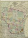
| Date: | 1870 |
|---|---|
| Description: | Map of Wisconsin showing counties and their county seats, towns and cities with over 3,000 inhabitants, the Detroit and Milwaukee Steam Ship Line, and both... |

| Date: | 1871 |
|---|---|
| Description: | Map of Wisconsin and portions of Minnesota, Michigan, Illinois and Iowa show the major railway tracks and their connections in red and blue ink. Lakes, riv... |

| Date: | 1871 |
|---|---|
| Description: | A map of Wisconsin which shows the counties, county seats, those cities with over 3,000 inhabitants. The map also depicts the rivers, lakes, completed and ... |

| Date: | 1872 |
|---|---|
| Description: | A series of four hand-colored, geological maps of Wisconsin. Starting from the top of the page, the first map is of a section along the line of the 4th pri... |

| Date: | 1872 |
|---|---|
| Description: | A map of Wisconsin which shows the counties, county seats, those cities with over 3,000 inhabitants. The map also displays the rivers, lakes, completed and... |
| Date: | 1873 |
|---|---|
| Description: | A map of Wisconsin along with southeastern Minnesota and Iowa, northern Illinois and the Upper Peninsula of Michigan, showing the counties, county seats, v... |

| Date: | 1873 |
|---|---|
| Description: | A hand-colored map of Minnesota, Wisconsin, and Michigan shows the counties, cities, villages, rivers, lakes, railroads, and steamboat routes in these stat... |

| Date: | 1873 |
|---|---|
| Description: | A hand-colored, geological map of the Fox and Wisconsin rivers’ water path from the Mississippi River to the Great Lakes. The map also shows those railroad... |
If you didn't find the material you searched for, our Library Reference Staff can help.
Call our reference desk at 608-264-6535 or email us at: