 Filter: Categories of Wisconsin Historical Images
Filter: COLLECTION_NAME of Map Collection
Filter: Year of 1800-1899
Filter: Community of Madison
Filter: Subject of streets
Filter: Categories of Wisconsin Historical Images
Filter: COLLECTION_NAME of Map Collection
Filter: Year of 1800-1899
Filter: Community of Madison
Filter: Subject of streets

| Date: | 1836 |
|---|---|
| Description: | The top map is the "Plat of Madison the Capitol of Wisconsin." The bottom map is the "Map of the Four Lake Country. Taken from the Township Maps in the U.S... |

| Date: | 1889 |
|---|---|
| Description: | Illustration of the exterior of the Fuller Opera House, which is a detail from a bird's-eye view map of Madison. |

| Date: | 1855 |
|---|---|
| Description: | Part of George Harrison's "Map of the City of Madison," showing the development of the isthmus and the small size of the second Capitol (54' x 104') in com... |

| Date: | 1896 |
|---|---|
| Description: | A portion of John B. Heim's map of the Water Works System of Madison showing the size of the third Wisconsin Capitol (228' x 226') in comparison with the C... |
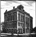
| Date: | 1889 |
|---|---|
| Description: | Madison City Hall, 2 West Mifflin Street built in 1857. |

| Date: | 1890 |
|---|---|
| Description: | Left half of a plat map of the "East Part of the city of Madison". |

| Date: | 1890 |
|---|---|
| Description: | Right side of a plat map of the "East Part of the City of Madison". |

| Date: | 1890 |
|---|---|
| Description: | Portion of a plat map of the "West Part of the City of Madison". |

| Date: | 1855 |
|---|---|
| Description: | Map of the city of Madison, Dane County, published by George Harrison, surveyed and drawn by P. McCabe, and engraved by J.H. Colton & Co., New York. In add... |

| Date: | 07 01 1836 |
|---|---|
| Description: | Original plat map of the town of Madison on the four lakes. |

| Date: | 1854 |
|---|---|
| Description: | Shows street grid, sections in adjacent townships, routes of railroads and projected railroads, post offices, and creeks. Table of references identifies ma... |

| Date: | 1887 |
|---|---|
| Description: | City water works system map. Pencil annotation on the top right reads: "Period represented is after 1887 and before Aug. 1891". The middle of the map has a... |

| Date: | 1873 |
|---|---|
| Description: | This map shows lots and blocks, additions and subdivisions, and large-scale landownership. The map is oriented with north to the upper right. The map is fr... |

| Date: | 1887 |
|---|---|
| Description: | Shows pipes of various sizes, hydrants with hydrant pressure, valves, wells, and projected lines. |

| Date: | 1892 |
|---|---|
| Description: | Shows pipes of various sizes, hydrants with hydrant pressure, valves, wells, and projected lines. Differs from earlier versions by inclusion of Wingra Park... |

| Date: | 1896 |
|---|---|
| Description: | Shows pipes of various sizes, hydrants with hydrant pressure, valves, wells, projected lines, and suction pipes. Differs from earlier versions by inclusion... |

| Date: | 1898 |
|---|---|
| Description: | Shows landownership, buildings, and railroads. Lake Mendota and Lake Wingra are labelled. |

| Date: | 1851 |
|---|---|
| Description: | This map shows plats with lots and block numbers of Madison. The far left corner features "University Ground" and some streets are labeled. Lake Monona is ... |

| Date: | 1871 |
|---|---|
| Description: | This map shows buildings, roads, the railroad, an orchard, and swamp land. Relief shown by hachures. The map includes an index of buildings in the upper ri... |

| Date: | 1855 |
|---|---|
| Description: | This map shows a plat of the city, local streets, numbered blocks and lots, university grounds, the Capitol Square, and parts of Third and Fourth Lakes (La... |
If you didn't find the material you searched for, our Library Reference Staff can help.
Call our reference desk at 608-264-6535 or email us at: