 Filter: Categories of Wisconsin Historical Images
Filter: COLLECTION_NAME of Map Collection
Filter: Subject of water
Filter: Creator Name of Sturgeon Bay and Lake Michigan Ship Canal and Harbor Company
Filter: Categories of Wisconsin Historical Images
Filter: COLLECTION_NAME of Map Collection
Filter: Subject of water
Filter: Creator Name of Sturgeon Bay and Lake Michigan Ship Canal and Harbor Company

| Date: | 1872 |
|---|---|
| Description: | This 1872 map shows the proposed route of a canal between Sturgeon Bay, on the Green Bay side of the Door Peninsula, and Lake Michigan. Depths in both Stur... |
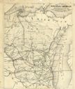
| Date: | 1878 |
|---|---|
| Description: | This map shows the advantages of the Sturgeon Bay and Lake Michigan Ship Canal, railroads, steamship lines across Lake Michigan, and Wisconsin township gri... |

| Date: | 1872 |
|---|---|
| Description: | This map includes depth shown by soundings and isolines and relief shown by contours. Tree species and locations are labeled, as well as a cranberry meadow... |
If you didn't find the material you searched for, our Library Reference Staff can help.
Call our reference desk at 608-264-6535 or email us at: