 Filter: Year of Pre-1600
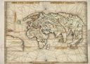
| Date: | 1513 |
|---|---|
| Description: | This exquisite woodcut map is one of the first to show any part of North America. It originally appeared in the 1513 Strasbourg edition of Ptolemy's Geogra... |
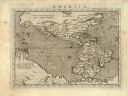
| Date: | 1576 |
|---|---|
| Description: | Map of America. This is the oldest map in the Parker collection. It is based on the geography of Ortelius, who is considered to be the creator of the first... |
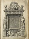
| Date: | 1570 |
|---|---|
| Description: | Frontispiece for Abraham Ortelius' Theatrum Orbis Terrarum, published in 1570, and considered the first modern atlas. Title is surrounded by four figures r... |

| Date: | 1556 |
|---|---|
| Description: | One of the earliest obtainable maps to accurately (for its time) depict the Americas, this map shows more decorative than descriptive features. A few river... |

| Date: | 1566 |
|---|---|
| Description: | Map showing the place names, rivers, and mountains of Europe, north-western Africa, the northern half of South America, and North America. Rhumb lines cros... |

| Community: | Milwaukee |
|---|---|
| County: | Milwaukee |
| Historic Name: | Chapelle of St. Martin de Sayssuel |
| Reference Number: | 110017 |

| Community: | Reedsburg |
|---|---|
| County: | Sauk |
| Historic Name: | |
| Reference Number: | 87732 |
If you didn't find the material you searched for, our Library Reference Staff can help.
Call our reference desk at 608-264-6535 or email us at:

