 Search: wisconsin
Filter: Subject of breweries
Filter: Subject of transportation
Search: wisconsin
Filter: Subject of breweries
Filter: Subject of transportation

| Date: | 1912 |
|---|---|
| Description: | Sanborn insurance map of the main street in Potosi, Wisconsin, with an inset for the Potosi Brewery. |

| Date: | 1870 |
|---|---|
| Description: | This 1870 map of Brown County, Wisconsin, shows the township and range grid, towns, sections, cities, villages and post offices, land ownership, roads, rai... |
| Date: | 1862 |
|---|---|
| Description: | John S. Fuller took this image of the third Wisconsin State Capitol (the second in Madison), from Governor Farwell's Octagon House, probably early in 1862.... |
| Date: | |
|---|---|
| Description: | View of the area behind the Fauerbach brewery. There is a Wil Kil sign on the building on the left. The dome of the Wisconsin State Capitol can be seen on ... |

| Date: | 1955 |
|---|---|
| Description: | Industries along the Milwaukee River, one of which is the Schlitz Brewery. |
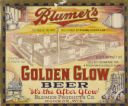
| Date: | 1933 |
|---|---|
| Description: | Label submitted to the State of Wisconsin for trademark registration. "Blumer's Golden Glow Beer, 'It's the After Glow', Blumer Products Co." The center of... |

| Date: | 1937 |
|---|---|
| Description: | Label submitted to the state of Wisconsin for trademark registration. "Pioneer Beer, G. Weber Brewing Co." Under this in the center is a leaf with the lett... |

| Date: | 1891 |
|---|---|
| Description: | The index page of a Sanborn Map of Stevens Point. |
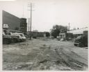
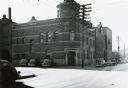
| Date: | 07 1952 |
|---|---|
| Description: | Train cars are parked near a tall building with a fire escape. |

| Date: | 1892 |
|---|---|
| Description: | A Sanborn fire insurance map of Sauk City which was drawn up in 1892. |

| Date: | 1915 |
|---|---|
| Description: | A Sanborn fire insurance map of Sauk City created in 1915. |

| Date: | 1900 |
|---|---|
| Description: | A Sanborn fire insurance map of Sauk City created in 1900. |
| Date: | 1885 |
|---|---|
| Description: | Exterior view of Fauerbach's Brewery at 651-53 Williamson Street. |
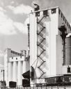
| Date: | 1947 |
|---|---|
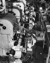
| Description: | Elevated view of workers on the bottling line at the Schlitz Brewery. |
| Date: | 1910 |
|---|---|
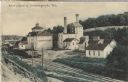
| Description: | Postcard of the Stork Brewery facilities. The image includes the brewery buildings along a hillside and railroad tracks in the foreground. There is a sign ... |

| Date: | 02 06 1905 |
|---|---|
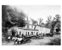
| Description: | Text on front reads: "Brewery, Shawano, Wis." The second Emit T. Raddant Brewing Company building, built in 1898. The brewery is six stories tall and built... |
| Date: | |
|---|---|
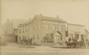
| Description: | Brewery wagons loaded with beer barrels in foreground of the Potosi Brewery. |

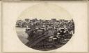
| Date: | 1898 |
|---|---|
| Description: | Bird's-eye map of Milwaukee with prominent streets and buildings identified. Taken from City Hall Tower. |
| Date: | 1939 |
|---|---|
| Description: | The old Fauerbach Brewery at 651-653 Williamson Street. The corner entrance is flanked by columns. |
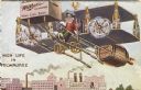
| Date: | 1911 |
|---|---|
| Description: | Humorous cartoon postcard showing a man flying an airplane constructed primarily of beer bottles, pretzels and sausages, and powered by Miller beer over th... |
If you didn't find the material you searched for, our Library Reference Staff can help.
Call our reference desk at 608-264-6535 or email us at: