 Search: wisconsin
Filter: Subject of breweries
Filter: Subject of factories
Filter: Subject of rivers
Search: wisconsin
Filter: Subject of breweries
Filter: Subject of factories
Filter: Subject of rivers
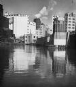
| Date: | 1955 |
|---|---|
| Description: | Industries along the Milwaukee River, one of which is the Schlitz Brewery. |

| Date: | 2007 |
|---|---|
| Description: | This map of Cedarbug is a bird's-eye map with 8 inset views and an index. The map is a print out of the original map dated 1892 held at the Cedarburg Cultu... |

| Date: | 09 1884 |
|---|---|
| Description: | Sanborn map of Fort Atkinson including Barrie, Germany, and North Water Streets. |

| Date: | 1883 |
|---|---|
| Description: | This map shows ward boundaries, names of additions, streets, bridges, mills, schools, religious buildings, businesses, hotels, railroads, factories, brewer... |
If you didn't find the material you searched for, our Library Reference Staff can help.
Call our reference desk at 608-264-6535 or email us at: