 Search: wisconsin
Filter: Subject of breweries
Filter: Subject of dwellings
Filter: Subject of transportation
Search: wisconsin
Filter: Subject of breweries
Filter: Subject of dwellings
Filter: Subject of transportation
| Date: | 1862 |
|---|---|
| Description: | John S. Fuller took this image of the third Wisconsin State Capitol (the second in Madison), from Governor Farwell's Octagon House, probably early in 1862.... |

| Date: | 1937 |
|---|---|
| Description: | Label submitted to the state of Wisconsin for trademark registration. "Pioneer Beer, G. Weber Brewing Co." Under this in the center is a leaf with the lett... |

| Date: | 1891 |
|---|---|
| Description: | The index page of a Sanborn Map of Stevens Point. |

| Date: | 1892 |
|---|---|
| Description: | A Sanborn fire insurance map of Sauk City which was drawn up in 1892. |

| Date: | 1915 |
|---|---|
| Description: | A Sanborn fire insurance map of Sauk City created in 1915. |

| Date: | 1900 |
|---|---|
| Description: | A Sanborn fire insurance map of Sauk City created in 1900. |
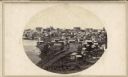
| Date: | 1930 |
|---|---|
| Description: | Panoramic elevated view to the east from the Capitol Square. |

| Date: | |
|---|---|
| Description: | Letterhead of the Chilton Branch of the Falk Jung & Borchert Brewing Company, headquartered in Milwaukee, Wisconsin. It includes, on the left, an elevated ... |

| Date: | 1878 |
|---|---|
| Description: | Bird's-eye map of Chilton with insets of points of interest, including P.H. Becker's Brewery, Chilton House, and Gutheil's Block. |

| Date: | 2007 |
|---|---|
| Description: | This map of Cedarbug is a bird's-eye map with 8 inset views and an index. The map is a print out of the original map dated 1892 held at the Cedarburg Cultu... |

| Date: | 1880 |
|---|---|
| Description: | Bird's-eye map over the Mississippi River of Fountain City. Paddle steamers and steamboats are on the river, and bluffs are in the background. |

| Date: | 1891 |
|---|---|
| Description: | Page 13 of a Sanborn map of Stevens Point. |

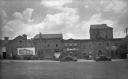
| Date: | |
|---|---|
| Description: | View across lawn and the Yahara River towards the Hausmann Brewing Company's Malt House in the center background. On the right is the Yahara River bridge. ... |

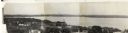
| Date: | |
|---|---|
| Description: | Aerial view of brewery, with the Mississippi River in the background. Text on reverse reads: "Aerial view of G. Heilman Brewing Co., Inc., La Crosse, Wisc.... |
| Date: | 1930 |
|---|---|
| Description: | View across lawn towards the Malt House at 1603 Sherman Avenue. To the right of the Malt House is the Cafferty Distributing Company, wholesalers for Schlit... |

| Date: | 03 27 1937 |
|---|---|
| Description: | View across water towards a well-dressed man and woman posing in front of a car while another man takes their photograph. A woman and young girl are lookin... |

| Date: | 09 1884 |
|---|---|
| Description: | Sanborn map of Fort Atkinson including Barrie, Germany, and North Water Streets. |
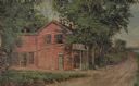
| Date: | 1931 |
|---|---|
| Description: | Drawing of the Melchoir House, which was a popular hostelry and brewery operated by Jacob Melchoir. It later became an Indian boarding house. |

| Date: | 1910 |
|---|---|
| Description: | Text on front reads: "1125 Cady Street, Watertown, Wis." The William Hartig Brewing Company with the Jacob Hoeffner home on the right. On the unpaved stree... |
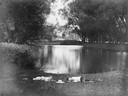
| Date: | |
|---|---|
| Description: | Two boys lying on the grass asleep in Tenney Park near the lagoon with a hat on the ground between them. The Sherman Avenue bridge and the Hausmann Brewery... |
If you didn't find the material you searched for, our Library Reference Staff can help.
Call our reference desk at 608-264-6535 or email us at: