Visit our other Wisconsin Historical Society websites!
 Search: wisconsin
Filter: Type of Photograph
Filter: Subject of land use
Filter: Subject of water
Search: wisconsin
Filter: Type of Photograph
Filter: Subject of land use
Filter: Subject of water

| Date: | 1930 |
|---|---|
| Description: | Aerial view of Wisconsin Dells including the Wisconsin River and the dam and generating power plant. |
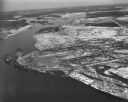
| Date: | 04 16 1949 |
|---|---|
| Description: | Aerial view of Necedah, Wisconsin, and Petenwell Lake behind Petenwell Dam on the Wisconsin River. |
| Date: | 04 18 1965 |
|---|---|
| Description: | Wisconsin River in flood, looking downstream. |
| Date: | 1948 |
|---|---|
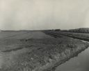
| Description: | Cranberry fields with irrigation ditches. |

| Date: | 1930 |
|---|---|
| Description: | Aerial view of the University of Wisconsin-Madison campus including Camp Randall Stadium, the Wisconsin State Capitol, and both Lake Mendota and Lake Monon... |

| Date: | 1922 |
|---|---|
| Description: | Aerial view of the Wisconsin State Capitol and Lake Monona. |
| Date: | 04 16 1949 |
|---|---|
| Description: | Aerial view of Castle Rock Dam on the Wisconsin River near Mauston, Wisconsin. |
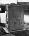
| Date: | 1929 |
|---|---|
| Description: | View of the George Stevens marker with the Wisconsin Auto Supply Company in the background and the Wisconsin River. |

| Date: | 1930 |
|---|---|
| Description: | Aerial view of the University of Wisconsin-Madison campus, the State Historical Society of Wisconsin building, Lake Mendota, residential areas and the surr... |

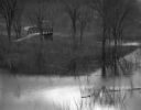
| Date: | 1930 |
|---|---|
| Description: | A farm and brook in Southern Wisconsin. Several trees hang over the brook along with a trace of snow. |

| Date: | 1930 |
|---|---|
| Description: | Aerial view of the Wisconsin State Capitol, the surrounding businesses, and Lake Monona. |
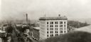
| Date: | 1927 |
|---|---|
| Description: | Elevated view looking east from the Wisconsin State Capitol down East Washington Avenue. |
| Date: | 04 18 1965 |
|---|---|
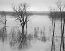
| Description: | A flooded woods near the Wisconsin River. A small bridge and a submerged road are in the background. |
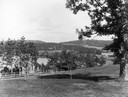
| Date: | |
|---|---|
| Description: | View from the Sherman House overlooking expansive lawn and river. |

| Date: | 03 16 1949 |
|---|---|
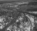
| Description: | Aerial view of Mauston, Wisconsin. |
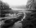
| Date: | 08 13 1961 |
|---|---|
| Description: | A Wisconsin River swamp. The swampy area is framed by trees with more trees in the background hidden by fog. |

| Date: | |
|---|---|
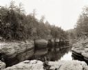
| Description: | View from shore of a covered bridge across the Wisconsin River. |

| Date: | 1926 |
|---|---|
| Description: | Originally titled 'Recent Aeroplane View of University Campus', the view of the Wisconsin Historical Society, the Red Gym, Science Hall and Bascom Hall wit... |
If you didn't find the material you searched for, our Library Reference Staff can help.
Call our reference desk at 608-264-6535 or email us at: