 Search: wisconsin
Filter: Type of Photograph
Filter: Subject of erosion
Search: wisconsin
Filter: Type of Photograph
Filter: Subject of erosion

| Date: | |
|---|---|
| Description: | View across water towards trees growing along steep, eroded cliffs at the shoreline. |

| Date: | |
|---|---|
| Description: | View over water towards trees growing along steep, eroded cliffs at the shoreline. |

| Date: | |
|---|---|
| Description: | View looking up to two waterfalls, which flow side by side. |

| Date: | |
|---|---|
| Description: | View between trees of a lake with high rock walls on one side. |

| Date: | |
|---|---|
| Description: | Elevated view of a hillside with trees, plants and grass, and a partially exposed face of eroded rock. |

| Date: | |
|---|---|
| Description: | View across water towards trees growing on the steep cliffs of a bluff at the shoreline. |

| Date: | |
|---|---|
| Description: | A man relaxing in a canoe on a river or lake. Behind him is a rock formation covered with trees. |

| Date: | |
|---|---|
| Description: | View across water towards trees growing on the steep cliffs of a bluff at the shoreline. There is a cave about halfway up the cliff. |

| Date: | |
|---|---|
| Description: | Elevated view from cliff of an arched-shaped rock formation towering over a lake below. The trees surrounding the lake are autumn colored. This appears to... |
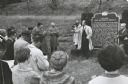
| Date: | 1960 |
|---|---|
| Description: | Senator Hubert Humphrey of Minnesota campaigning for the presidential nomination in southwestern Wisconsin. Humphrey stands at the historical marker in Co... |

| Date: | |
|---|---|
| Description: | View along shoreline of a lake towards a man standing near the mouth of a cave at the waterline. The cave is in steep, eroded cliffs, and trees and shrubs ... |

| Date: | 1928 |
|---|---|
| Description: | T. N19 R. 4W about section 19, McPeak farm. A 50 foot deep ravine is seen rapidly eating its way toward farm buildings. |

| Date: | 1911 |
|---|---|
| Description: | Elevated view of the erosion caused by the 1911 Flood in Black River Falls. Houses are hanging off the edge of the river. |

| Date: | 1911 |
|---|---|
| Description: | View along shoreline of the Black River after the 1911 flood. The banks are eroded, and power lines are downed. |

| Date: | 1911 |
|---|---|
| Description: | Elevated view of the Black River after the 1911 flood. Severely eroded banks are on the left. |

| Date: | |
|---|---|
| Description: | View of a dirt field showing signs of wind erosion. Farm buildings, a fence and fields are in the distance. |
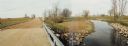
| Date: | 10 26 1986 |
|---|---|
| Description: | Green Elm Road Bridge over the east fork of Hemlock Creek, showing the rocks used to prevent erosion. |
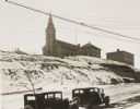
| Date: | 1934 |
|---|---|
| Description: | Terracing on Ellis Street during the winter. Two automobiles are parked alongside the road in the foreground. The terraced hill is snow covered, and a chur... |

| Date: | 1911 |
|---|---|
| Description: | Elevated view of damage to buildings after the 1911 flood of the Black River. Wooden debris is floating in the flood water and encroaching the shoreline. |

| Date: | 1911 |
|---|---|
| Description: | View along shoreline of damage from the 1911 flood of the Black River. An entire wall of a building is gone, and debris is along the river banks. |
If you didn't find the material you searched for, our Library Reference Staff can help.
Call our reference desk at 608-264-6535 or email us at: