 Search: railroad
Filter: Community of La Crosse
Filter: Subject of mississippi river
Search: railroad
Filter: Community of La Crosse
Filter: Subject of mississippi river
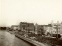
| Date: | 1905 |
|---|---|
| Description: | View from the top of a railroad car on railroad tracks along the Mississippi River shoreline. Ships are along the shoreline on the right, and railroad trac... |
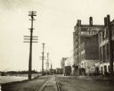
| Date: | 1900 |
|---|---|
| Description: | View down railroad tracks, with the Mississippi River on the left, and on the right the J.J. Hogan Wholesale Company. |

| Date: | 1880 |
|---|---|
| Description: | This map of La Crosse shows the Chicago, Milwaukee and St. Paul Railroad, the Southern Minnesota Railroad and the Chicago, Dubuque and Minnesota Railroad, ... |

| Date: | 1873 |
|---|---|
| Description: | Bird's-eye map of La Crosse from the Mississippi River. |

| Date: | 1873 |
|---|---|
| Description: | The harbor, showing the sidewheel packet, "Belle of La Crosse," and the sidewheel ferry "Alex McGregor." Other boats are also seen including two barges loa... |
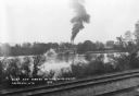
| Date: | 1943 |
|---|---|
| Description: | View across railroad tracks along the shorline of the Mississippi River towards the stern wheeled steamboat General Allen towing barges upriver at L... |

| Date: | 1873 |
|---|---|
| Description: | A map that covers parts of Winona and Houston Counties, Minnesota and La Crosse County, Wisconsin, showing the proposed railroad routes, constructed rail l... |
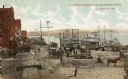
| Date: | 1910 |
|---|---|
| Description: | Elevated view over the Mississippi River towards the waterfront in La Crosse. |

| Date: | 1911 |
|---|---|
| Description: | Elevated view of the John Gund Brewing Company buildings, with the Mississippi River in the background. Caption reads: "John Gund Brewing Co., La Crosse, W... |

| Date: | 1868 |
|---|---|
| Description: | The sidewheel packet, Keokuk, loaded with passengers beside a barge at a landing. The landing is filled with people and horse-drawn vehicles. The si... |
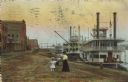
| Date: | 1910 |
|---|---|
| Description: | Caption reads: "Riverfront from Pettibone Park, La Crosse, Wis." There are three steamboats docked on the right in the harbor. A mother and her children ar... |

| Date: | 1927 |
|---|---|
| Description: | This map includes an index and highways marked in red. Attractions on the map include: Four Mile House, Cold Springs, Grand Crossing Station, Coleman Sloug... |

| Date: | 1954 |
|---|---|
| Description: | This map of La Crosse shows residential, multiple dwelling, local business, commercial, light industrial, heavy industrial and special multiple dwelling la... |

| Date: | 1886 |
|---|---|
| Description: | This map has relief shown by hachures and includes a list of plats in order of date of record, laws which vacate plats, plats not shown as upon the county ... |

| Date: | 1859 |
|---|---|
| Description: | This map show plats including plat names, plat numbers, and some lot owner's names. Relief is shown by hachures. The map includes line drawings of Juneau B... |
If you didn't find the material you searched for, our Library Reference Staff can help.
Call our reference desk at 608-264-6535 or email us at: