 Search: railroad
Filter: Type of Map or Atlas
Filter: Subject of land
Search: railroad
Filter: Type of Map or Atlas
Filter: Subject of land

| Date: | 1882 |
|---|---|
| Description: | The official railroad map of Wisconsin showing railroad lines throughout the state. |

| Date: | 1884 |
|---|---|
| Description: | The official railroad map of Wisconsin showing railroad lines throughout the state. |
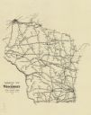
| Date: | 1929 |
|---|---|
| Description: | This map shows railroad routes throughout the state. |

| Date: | 1867 |
|---|---|
| Description: | A map showing railroad land in Chippewa Valley. |

| Date: | 1856 |
|---|---|
| Description: | A Wisconsin map showing the Wisconsin Superior and St. Croix Railroad. |

| Date: | 1868 |
|---|---|
| Description: | This 1868 birds-eye view depicts the buildings, streets, railroad, vegetation and topography of Columbus, Wisconsin. The high school, cemetery, railroad de... |

| Date: | 1896 |
|---|---|
| Description: | Map showing the Wisconsin Central Railroad and its land grant, with the railroad and the land grant in color (red). |

| Date: | 1871 |
|---|---|
| Description: | Map created between 1871 and 1880. Shows townships, post offices, a possible railroad to Penoka Iron Range, and the North Wisconsin Railroad. |

| Date: | 1851 |
|---|---|
| Description: | Map of the Lake Superior region showing the railroad and steamboat connection. |

| Date: | 1900 |
|---|---|
| Description: | This map shows railroad routes in red, blue, orange, brown, pink, green, and dotted, as well as lakes, rivers, and communities. The map includes a legend i... |

| Date: | 1880 |
|---|---|
| Description: | This map of La Crosse shows the Chicago, Milwaukee and St. Paul Railroad, the Southern Minnesota Railroad and the Chicago, Dubuque and Minnesota Railroad, ... |
| Date: | 1970 |
|---|---|
| Description: | This blue line print map shows the railroad lines. Cities are also labeled. |
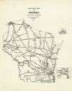
| Date: | 1957 |
|---|---|
| Description: | This map shows railroad routes and includes inset maps of Superior and vicinity and Milwaukee and vicinity. |
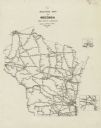
| Date: | 1945 |
|---|---|
| Description: | This map shows railroad routes and includes inset maps of Superior and vicinity and Milwaukee and vicinity. |

| Date: | 1856 |
|---|---|
| Description: | A map showing rail lines in Wisconsin and the railroad land grants of the Superior & St. Croix Railroad in the present-day northwestern Wisconsin counties ... |

| Date: | 1878 |
|---|---|
| Description: | Illustrated map of Crawford County. On the bottom right is an inset of a group of people near a train on a railroad track. |

| Date: | 07 27 1874 |
|---|---|
| Description: | Map of a railroad line from Mantiowoc to Appleton ending at Lake Michigan. The railroad appears in red ink. The ranges are divided and numbered. Map is ink... |

| Date: | 1871 |
|---|---|
| Description: | A map of California showing railroad lines and reservations. |
If you didn't find the material you searched for, our Library Reference Staff can help.
Call our reference desk at 608-264-6535 or email us at:

