 Search: logging
Filter: Subject of lakes
Search: logging
Filter: Subject of lakes
| Date: | |
|---|---|
| Description: | View across water towards logs floating along the lake. Several buildings, including a water tower and a silo, are on the opposite shoreline. |
| Date: | |
|---|---|
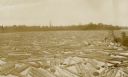
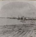
| Description: | View of a lake with logs nearly covering the surface. A man is standing on a log near the shoreline. |

| Date: | 1853 |
|---|---|
| Description: | This map shows camps, forts, logging camps, lakes, roads, railroads, the Wisconsin River, and Lac Du Flambeau Indian Reservation. Some points of interest a... |

| Date: | 1969 |
|---|---|
| Description: | This map shows ghost towns, Indian reservations, lakes, railroads, and rivers. Ghost towns are numbered and listed in a corresponding index. |

| Date: | 1900 |
|---|---|
| Description: | This map shows logging roads, railroads with spur lines, trails, rapids, lumber camps, Indian villages, summer resort, lakes, rivers, and ponds. |
| Date: | 1912 |
|---|---|
| Description: | This view is looking northeast from the site of Norway Springs at the north end of Trout Lake in the spring. In the foreground are tree stumps; in the back... |

| Date: | 1900 |
|---|---|
| Description: | Cove Logging camp at future site of Forest Lodge property. The log building on the hill became the main house at Forest Lodge in 1902 when Crawford Livings... |
| Date: | 1940 |
|---|---|
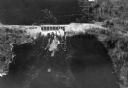
| Description: | Aerial view, looking upstream, of water flowing through a dam. On the reverse of the print is written: "Dam built by WPA on site of old logging dam on the ... |
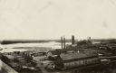
| Date: | 1900 |
|---|---|
| Description: | Elevated view of a lumber plant, with large stacks of lumber stacked around it. A lake is behind the plant. |
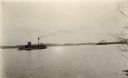
| Date: | |
|---|---|
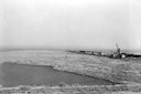
| Description: | View across water towards a tow boat on the lake. Two men are standing on the top of the boat near a chimney spewing smoke. |
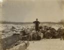
| Date: | 1890 |
|---|---|
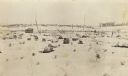
| Description: | View of a man standing on a log among a large pile of logs spread out on the snow-covered ice of a lake. He is leaning on the handle of what may be a cant ... |
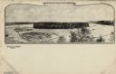
| Date: | |
|---|---|
| Description: | Black and white illustration of Half Moon Lake with log jams and an island. Caption reads: "Half Moon Lake and Island, Eau Claire, Wis." |

| Date: | 1920 |
|---|---|
| Description: | This manuscript map of southern Bayfield County, Wisconsin, covers the towns of Cable and Drummond and portions of Grandview and Namekagon. Shown are the t... |
| Date: | 1900 |
|---|---|
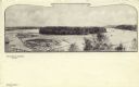
| Description: | Black and white elevated view of Half Moon Lake and Island. Logs are in a boom in the lake. Caption reads: "Half Moon Lake and Island," and "Eau Claire, Wi... |
| Date: | 1936 |
|---|---|
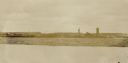
| Description: | Elevated view of logs tugged across Lake Superior to the harbor at Ashland. |

| Date: | 1881 |
|---|---|
| Description: | A brochure with a map of Wisconsin that also includes information (in English, German, Norwegian, and Swedish) pertaining to the state, such as its timber ... |
| Date: | 1871 |
|---|---|
| Description: | Stereograph of a sawmill area and Lake Winnebago in the foreground. The square building with the "cupola" was the Revere House. A manuscript notation, very... |
If you didn't find the material you searched for, our Library Reference Staff can help.
Call our reference desk at 608-264-6535 or email us at:
