 Search: birds
Search: eye
Filter: Subject of water
Search: birds
Search: eye
Filter: Subject of water
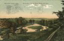
| Date: | 1909 |
|---|---|
| Description: | Colorized postcard of an elevated view of a river with a dam in the distance. Caption reads: "Beaver Dam, Wis. Birds-eye View of River Below the Dam." |
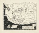
| Date: | |
|---|---|
| Description: | A pen drawing, in the style of a birds-eye map, of Frank and Delia King's estate Folly Farm in Kissimee, Florida. |

| Date: | |
|---|---|
| Description: | Photographic postcard of an elevated view of a lake with boathouses along the shore and dwellings in the distance. Caption reads: "Birds Eye View from Cott... |

| Date: | 1908 |
|---|---|
| Description: | Elevated view of Holcombe, with the dam on the Chippewa River in the foreground. Caption reads: "Birds-Eye View, Holcombe, Wis." |

| Date: | 1868 |
|---|---|
| Description: | This 1868 birds-eye view depicts the buildings, streets, railroad, vegetation and topography of Columbus, Wisconsin. The high school, cemetery, railroad de... |
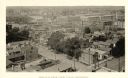
| Date: | 1888 |
|---|---|
| Description: | Elevated view from the northwest of the Racine Court House. Caption reads: "Birds-Eye from Court House, Northwest." |

| Date: | 1916 |
|---|---|
| Description: | Birds-eye view of the University of Wisconsin-Madison campus. The Armory (Red Gym), Science Hall and State Historical Society are in the foreground. Main H... |

| Date: | 1870 |
|---|---|
| Description: | Bird's-eye view of Whitewater, with insets. |

| Date: | 1917 |
|---|---|
| Description: | Bird's-eye view of the University of Wisconsin-Madison campus. |
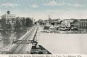
| Date: | 1910 |
|---|---|
| Description: | Elevated view of the Northwestern Manufacturing Company plant. Caption reads: "Birds-eye View showing Northwestern Mfg. Co.'s Plant, Fort Atkinson, Wis." |

| Date: | 1928 |
|---|---|
| Description: | Birds-eye view showing Lake Mendota, Lake Monona, Lake Wingra, Lake Waubesa and Lake Kegonsa. Shows the growth of Madison from the Isthmus along the southe... |

| Date: | 1867 |
|---|---|
| Description: | Birds eye drawing of Fond du Lac depicts street names and street layouts, houses, buildings, trees, and the Fond du Lac River. A reference key at the botto... |

| Date: | 1871 |
|---|---|
| Description: | Birds eye map of Brodhead, WI depicts street names and street locations, houses, and trees. A reference key at the bottom of the map shows the locations of... |

| Date: | 1869 |
|---|---|
| Description: | Birds-eye drawing of Boscobel, Grant County, depicts street names and street layouts, houses, rivers and trees. A reference key at the bottom of the map sh... |

| Date: | 1870 |
|---|---|
| Description: | Birds eye drawing of Fort Atkinson, Jefferson County, depicts street names and street layouts, houses, trees, Rock River and Bark River. A reference key at... |

| Date: | 1874 |
|---|---|
| Description: | Birds-eye view of Appleton Wisconsin. In the foreground are people fishing, strolling, and looking over the canal towards the Fox River. Streets and buildi... |

| Date: | 1870 |
|---|---|
| Description: | During the War of 1812, the only battle fought in Wisconsin was in Prairie du Chien, in 1814. Made fifty-six years later, this birds eye drawing depicts th... |

| Date: | 1915 |
|---|---|
| Description: | Advertisement reads: "Castle-Pierce Printing Company" and "Feb. 1915". Text on right reads: "The Heart of Oshkosh. This birds-eye view represents about one... |

| Date: | 1867 |
|---|---|
| Description: | Birds-eye drawing of Beaver Dam, Dodge Co., depicting street names and street layout, houses, rivers, lakes, and trees. A reference key at the bottom of th... |

| Date: | 1871 |
|---|---|
| Description: | Birds eye map of New London depicts street names and street locations, houses, trees, the bridge, Wolf River, and the bayou. At the bottom of the map, a re... |
If you didn't find the material you searched for, our Library Reference Staff can help.
Call our reference desk at 608-264-6535 or email us at: