 Search: Wisconsin
Search: Historical
Filter: Categories of Wisconsin Historical Images
Filter: Subject of streams
Search: Wisconsin
Search: Historical
Filter: Categories of Wisconsin Historical Images
Filter: Subject of streams

| Date: | 1886 |
|---|---|
| Description: | This map, originally published in the 1881 Illustrated historical atlas of Wisconsin, shows the township and range system, sections,towns, cities and villa... |
| Date: | 07 1895 |
|---|---|
| Description: | Two men, W.M. Smith and W.H.D., rest on a large log over Little Bear Creek. |

| Date: | 1906 |
|---|---|
| Description: | A map of Berlin, Wisconsin and the surrounding area, showing the old channel of the Fox River and the site of Mascouten village just south of that city in ... |
| Date: | 1912 |
|---|---|
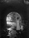
| Description: | Hattie Taylor and daughter Tannisse walk under a Milwaukee park culvert. |

| Date: | 07 19 1917 |
|---|---|
| Description: | View of a small foot bridge over a stream. This postcard was sent to a Miss M.S. Fester at the State Historical Library, who donated it on May 2, 1918. On ... |

| Date: | 1930 |
|---|---|
| Description: | A farm and brook in Southern Wisconsin. Several trees hang over the brook along with a trace of snow. |

| Date: | 1939 |
|---|---|
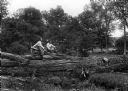
| Description: | Two men, a young boy, and two women relax by a tree near a stream. |

| Date: | 1945 |
|---|---|
| Description: | Elevated view across water towards Holstein cattle in a pasture. Caption from calendar: "A Holstein dairy herd — Polk county. Wisconsin's fame as America's... |

| Date: | 1948 |
|---|---|
| Description: | Slightly elevated view of two men snowshoeing along a flowing stream near Trout Lake. |

| Date: | 1949 |
|---|---|
| Description: | Black Earth Creek in the winter, with the banks covered with snow. Large trees are leaning over the creek on the right bank. In the background are a fence,... |
| Date: | 1949 |
|---|---|
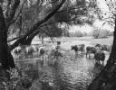
| Description: | A Guernsey herd in a stream near a pasture. Trees line the banks. |
| Date: | 10 07 1950 |
|---|---|
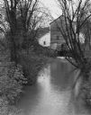
| Description: | Grist mill on a river. In the foreground is the mill stream with trees and shrubs on the shorelines. |
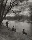
| Date: | 1951 |
|---|---|
| Description: | First fishing near Vilas Park on Murphy's Creek (now known as Wingra Creek.) Many people are set up to fish on both sides of the tree-lined banks. |
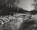
| Date: | 1951 |
|---|---|
| Description: | View along the snow-covered banks of a creek which is steaming in the extreme cold. There are trees growing in the hilly landscape, and the tops of shrubs ... |
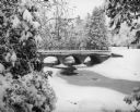
| Date: | 12 11 1953 |
|---|---|
| Description: | Snow scene of a concrete bridge with three arches, over a creek, in Silver Creek Park. The creek is mostly frozen and surrounded by snow covered trees. |
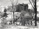
| Date: | 1955 |
|---|---|
| Description: | Wheeler Hall at Northland College, during winter. A group of people are on a bridge over the Bay City Creek, surrounded by trees, in the foreground. Wheele... |
| Date: | 03 11 1956 |
|---|---|
| Description: | Open water on a stream in spring. Snow is along the banks, and shadows of trees are on a snow-covered hill in the background. |

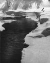
| Date: | 11 1958 |
|---|---|
| Description: | Black Earth Creek with November Snow. The water meanders and a large tree grows on the bank. |

| Date: | 1960 |
|---|---|
| Description: | This standard U.S.G.S. topographic map was annotated by civil engineer and railroad historian James P. Kaysen to show the location of existing and defunct ... |
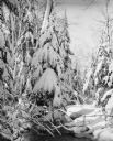
| Date: | 1961 |
|---|---|
| Description: | A narrow stream running under trees. The trees and banks are covered with fresh snow. |
If you didn't find the material you searched for, our Library Reference Staff can help.
Call our reference desk at 608-264-6535 or email us at: