 Search: Wisconsin
Search: Historical
Filter: Categories of Wisconsin Historical Images
Filter: Subject of express highways
Search: Wisconsin
Search: Historical
Filter: Categories of Wisconsin Historical Images
Filter: Subject of express highways

| Date: | 1919 |
|---|---|
| Description: | Narrow red lines show principal secondary highways. Green circles shows points of historical interest. Green triangles show Indian mounds and Indian villag... |

| Date: | 1930 |
|---|---|
| Description: | Exterior view of the Triangle filling station on Highway 12, which sold gasoline, ice, and other items. A man stands in front by the gas pump, and a map of... |

| Date: | 1961 |
|---|---|
| Description: | Evacuation route out of Milwaukee. View from the side of the road looking downhill towards the rear of a Wisconsin State Patrol cruiser parked on the right... |
| Date: | 1969 |
|---|---|
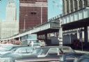
| Description: | View of the construction of the World Trade Center from a nearby parking lot. |

| Date: | 1969 |
|---|---|
| Description: | A man is driving a construction truck in the shadow cast by what appears to be an elevated highway. A sign for the "Brooklyn Battery Tunnel" is on one of t... |
| Date: | 1971 |
|---|---|
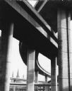
| Description: | A view of the underside of a highway interchange. Steeples of a church are in the background. |

| Date: | 1982 |
|---|---|
| Description: | This standard U.S.G.S. topographic map was annotated by civil engineer and railroad historian James P. Kaysen to show the location of existing and defunct ... |
| Date: | 1986 |
|---|---|
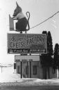
| Description: | Warner Creek Cheese billboard, including a 3D sculpture of a mouse with cheese, in front of a small, brick building. Located off the State Highway near Hil... |

| Date: | 2008 |
|---|---|
| Description: | View down highway as a truck is driving towards a foggy horizon as the sun is rising. The photographer was on his way to Madison when this picture was take... |

| Date: | |
|---|---|
| Description: | A brochure and map of Jefferson County, Wisconsin, which includes color illustrations, a highway map of the county, a location map, and descriptions of poi... |
If you didn't find the material you searched for, our Library Reference Staff can help.
Call our reference desk at 608-264-6535 or email us at: