 Search: Wisconsin
Search: Historical
Filter: Categories of Wisconsin Historical Images
Filter: Subject of aerial photographs
Search: Wisconsin
Search: Historical
Filter: Categories of Wisconsin Historical Images
Filter: Subject of aerial photographs
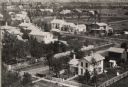
| Date: | 1865 |
|---|---|
| Description: | Aerial view of a residential part of Janesville. |
| Date: | 1923 |
|---|---|
| Description: | Aerial view of the University of Wisconsin campus shows from west to east the Agricultural Hall, Observatory Hall and the Wisconsin Historical Society with... |

| Date: | 1923 |
|---|---|
| Description: | Aerial view of the Wisconsin Historical Society, Science Hall, and Bascom Hall on Bascom Hill on the University of Wisconsin-Madison campus. Lake Mendota i... |

| Date: | 1926 |
|---|---|
| Description: | Originally titled 'Recent Aeroplane View of University Campus', the view of the Wisconsin Historical Society, the Red Gym, Science Hall and Bascom Hall wit... |

| Date: | 1928 |
|---|---|
| Description: | University of Wisconsin-Madison, looking west. Lake Mendota and Picnic Point are in the upper right of the image. Bascom Hall, the Red Gym, the Wisconsin H... |

| Date: | 1930 |
|---|---|
| Description: | Aerial view of the University of Wisconsin-Madison campus, the State Historical Society of Wisconsin building, Lake Mendota, residential areas and the surr... |

| Date: | 1945 |
|---|---|
| Description: | Aerial view of Bascom Hill, Bascom Hall, Wisconsin Historical Society on the University of Wisconsin Madison campus with Lake Mendota on the right. |

| Date: | 1945 |
|---|---|
| Description: | View of the lower campus of the University of Wisconsin-Madison includes Bascom Hill, Wisconsin Historical Society, Memorial Union and the Armory (Red Gym ... |
| Date: | 1945 |
|---|---|
| Description: | An aerial view of Truax Field, now also called Dane County Regional Airport. In addition to commercial flights, Truax Field is also home to the Army Nation... |

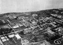
| Date: | 1947 |
|---|---|
| Description: | Aerial view of the Forest Products Laboratory. |
| Date: | 1947 |
|---|---|
| Description: | Aerial of University of Wisconsin-Madison campus with Camp Randall in the lower right corner and Lake Mendota, looking northeast to Maple Bluff. |

| Date: | 1948 |
|---|---|
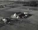
| Description: | Aerial view of a farm in mid-winter. Snow blankets the ground and some of the buildings. An orchard is in the foreground. |
| Date: | 1948 |
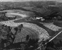
|---|---|
| Description: | Aerial view of terraced farm land with shocks of harvested corn. A farm is in the valley and trees cover much of the hills. |
| Date: | 09 17 1948 |
|---|---|
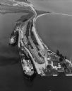
| Description: | Aerial view of two Lake Michigan ferries tied up at harbor slips. The eastern terminus of the Green Bay Route was the Lake Michigan port city of Kewaunee. ... |
| Date: | 10 05 1948 |
|---|---|
| Description: | Aerial photograph of the Baumgartner Dairy Farm, one half mile east of Three Lakes, WI. |

| Date: | 07 10 1949 |
|---|---|
| Description: | Aerial view of Minocqua showing the surrounding lakes. |

| Date: | 1950 |
|---|---|
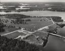
| Description: | Aerial view of the Highway 21 bridge and Petenwell Dam on the Wisconsin River. |

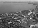
| Date: | 1950 |
|---|---|
| Description: | Aerial view of the Wisconsin State Capitol building and surrounding Madison area. Lake Monona is in the background. |
| Date: | 1950 |
|---|---|
| Description: | Aerial view of Northernaire Resort, on Deer Lake. The resort is in the foreground. Many lakes, surrounded by trees, are in the background, including Big St... |

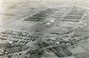
| Date: | 1950 |
|---|---|
| Description: | Aerial view of contour farming surrounding multiple farms and woods. |
If you didn't find the material you searched for, our Library Reference Staff can help.
Call our reference desk at 608-264-6535 or email us at: