 Search: Wisconsin
Search: Historical
Search: Calendar
Filter: Categories of Wisconsin Historical Images
Filter: Subject of human settlements
Filter: Subject of intellectual life
Search: Wisconsin
Search: Historical
Search: Calendar
Filter: Categories of Wisconsin Historical Images
Filter: Subject of human settlements
Filter: Subject of intellectual life

| Date: | 1880 |
|---|---|
| Description: | Alma was platted and settled in 1855, on a narrow strip of land between high bluffs and the Mississippi River. Its location made it a popular shipping cent... |
| Date: | 1898 |
|---|---|
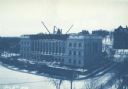
| Description: | Elevated view across Langdon Street of the Wisconsin State Historical Society building under construction in winter with snow on the ground. A group of men... |
| Date: | 1911 |
|---|---|
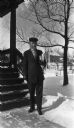
| Description: | A college student setting out to class in zero degree weather. He is holding his books, and is wearing a hat and gloves, and has a scarf wrapped around his... |

| Date: | 1912 |
|---|---|
| Description: | Otto G. Ansorge sits in his home on Lake Avenue and reads. Ansorge was a jeweler and band director in Winneconne. |
| Date: | 06 27 1912 |
|---|---|
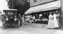
| Description: | Suffragist Mrs. Katherine McCullough speaking to a gathering in front of the store and post office run by Mrs. W. Bunda in Sister Bay. |
| Date: | 1915 |
|---|---|
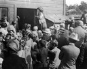
| Description: | Belle Case La Follette, wife of Robert M. La Follette, Sr., addressing a group of farmers during a tour on the Chautauqua circuit during which she frequent... |
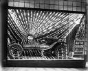
| Date: | 1920 |
|---|---|
| Description: | An automobile on display for the twelfth annual Milwaukee Auto Dealers show. The show was held January 19-25. |
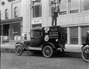
| Date: | 1928 |
|---|---|
| Description: | Standing atop a special vehicle fitted with a body built to resemble a camera, Taylor found the ideal vantage point from which to cover a news event. The c... |

| Date: | 1930 |
|---|---|
| Description: | Exterior view of the Triangle filling station on Highway 12, which sold gasoline, ice, and other items. A man stands in front by the gas pump, and a map of... |

| Date: | 10 01 1938 |
|---|---|
| Description: | J. Robert Taylor cleaning a furnace. He has a broom and a small brush in hand, a pipe in his mouth, and a dirty rag placed on his head. He is reading a doc... |
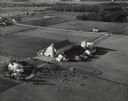
| Date: | 1945 |
|---|---|
| Description: | An aerial view of Truax Field, now also called Dane County Regional Airport. In addition to commercial flights, Truax Field is also home to the Army Nation... |

| Date: | 1947 |
|---|---|
| Description: | Aerial view of the Forest Products Laboratory. |
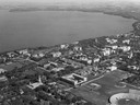
| Date: | 1947 |
|---|---|
| Description: | Aerial of University of Wisconsin-Madison campus with Camp Randall in the lower right corner and Lake Mendota, looking northeast to Maple Bluff. |
| Date: | 10 05 1948 |
|---|---|
| Description: | Aerial photograph of the Baumgartner Dairy Farm, one half mile east of Three Lakes, WI. |

| Date: | 07 10 1949 |
|---|---|
| Description: | Aerial view of Minocqua showing the surrounding lakes. |

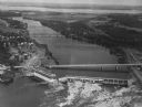
| Date: | 1950 |
|---|---|
| Description: | Aerial view of the Highway 21 bridge and Petenwell Dam on the Wisconsin River. |

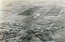
| Date: | 1950 |
|---|---|
| Description: | Aerial view of contour farming surrounding multiple farms and woods. |

| Date: | 1950 |
|---|---|
| Description: | Aerial view of the Wisconsin State Capitol building and surrounding Madison area. Lake Monona is in the background. |
| Date: | 1950 |
|---|---|
| Description: | Aerial view of a hydroelectric power plant owned by Northern States Power Company located on the Chippewa River. A highway bridge and a railroad bridge spa... |
If you didn't find the material you searched for, our Library Reference Staff can help.
Call our reference desk at 608-264-6535 or email us at:
