 Search: Wisconsin
Search: Historical
Search: Calendar
Filter: Categories of Wisconsin Historical Images
Filter: Subject of hills
Filter: Subject of aerial photographs
Search: Wisconsin
Search: Historical
Search: Calendar
Filter: Categories of Wisconsin Historical Images
Filter: Subject of hills
Filter: Subject of aerial photographs
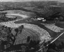
| Date: | 1948 |
|---|---|
| Description: | Aerial view of terraced farm land with shocks of harvested corn. A farm is in the valley and trees cover much of the hills. |

| Date: | 1950 |
|---|---|
| Description: | Aerial view of a farm and surrounding fields farmed with the contour method. Shocks of grain dot several of the fields. |

| Date: | 11 1951 |
|---|---|
| Description: | Aerial view of US Highway 14 southeast of La Crosse descending into Mormon Coulee. The original caption of the print, which is undated, describes the road ... |
If you didn't find the material you searched for, our Library Reference Staff can help.
Call our reference desk at 608-264-6535 or email us at: