 Search: Wisconsin
Search: Historical
Search: Calendar
Filter: Categories of Wisconsin Historical Images
Filter: Subject of formations (geology)
Search: Wisconsin
Search: Historical
Search: Calendar
Filter: Categories of Wisconsin Historical Images
Filter: Subject of formations (geology)

| Date: | 1895 |
|---|---|
| Description: | View across water towards a house on the banks of the Mississippi River at the base of rocky bluffs. Probably located between Alma and Nelson, along Beef S... |
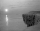
| Date: | 1912 |
|---|---|
| Description: | Sunrise over a frozen cliff on Lake Michigan. |

| Date: | 1930 |
|---|---|
| Description: | A winter view of "The Three Chimneys" in the St. Peter sandstone formation. |

| Date: | 1945 |
|---|---|
| Description: | Totem Pole Room at the Cave of the Mounds. Caption on back of print reads: "The Totem Pole Room is popular with visitors because of the rich coloring and r... |
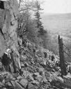
| Date: | 1945 |
|---|---|
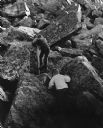
| Description: | University students on a field trip to Devil's Lake State Park climb the trail up through the piles of talus (broken rocks) on the slope. A couple in the f... |
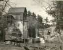
| Date: | 1948 |
|---|---|
| Description: | Abandoned mill, formerly called the Modena Roller Mills. The first mill was built in 1865 (now torn down). |
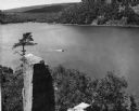
| Date: | 1948 |
|---|---|
| Description: | View from the east bluff of lake with a motorboat. A geologic pinnacle juts out from the lower left of the image. |

| Date: | 1950 |
|---|---|
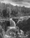
| Description: | Copper Falls plunging over rocks on the Bad River in Copper Falls State Park. |
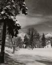
| Date: | 1950 |
|---|---|
| Description: | Trees and snow, with buildings behind trees in the background. In the far background are hills or bluffs with rocky outcroppings. |

| Date: | 1950 |
|---|---|
| Description: | Castle Rock, surrounded by trees and a meadow. The geological feature is near Volk Field Air National Guard Base. |
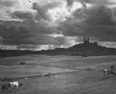
| Date: | 1950 |
|---|---|
| Description: | Dramatic view of Holy Hill against a sky full of clouds. In the foreground, cows are grazing in fenced fields. |

| Date: | 1950 |
|---|---|
| Description: | View of an automobile traveling north on Highway 35, near the Mississippi River. Railroad tracks run between the road and the river. In the background are ... |
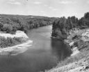
| Date: | 1951 |
|---|---|
| Description: | Elevated view of the Black River, with rock outcroppings, sand bars and trees. It is approximately 190 miles long and is a tributary of the Mississippi Riv... |
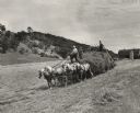
| Date: | 1952 |
|---|---|
| Description: | A woman is driving a horse-drawn hay wagon pulling a hay loader on the William Houser Farm. A child and a man, each with a hay fork, are riding on the load... |
| Date: | 08 1952 |
|---|---|
| Description: | Copper Falls in Copper Falls State Park. The falls are on the Bad River. A group of people are standing on the rocks on the right. Trees are in the backgro... |
| Date: | 1960 |
|---|---|
| Description: | Rock formation, Devil's Doorway, in the snow. In the background Devil's Lake is frozen and bluffs are in the background. |
| Date: | 1962 |
|---|---|
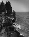
| Description: | Pine trees at the edge of the rocky shoreline in High Cliff Park on Lake Michigan. |
| Date: | 09 1968 |
|---|---|
| Description: | View looking up at two boys climbing the tumbled slabs of rock at Devil's Lake State Park. |
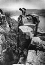
| Date: | 1976 |
|---|---|
| Description: | View towards a rock climber on top of an outcropping at Devil's Lake State Park who is watching another climber descending. Devil's Lake and bluffs are in ... |
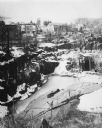
| Date: | 1977 |
|---|---|
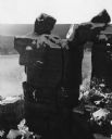
| Description: | Elevated view across a granite quarry looking west, with Buffalo Lake in the background. Buildings of the town are between the quarry and the lake, and a p... |
If you didn't find the material you searched for, our Library Reference Staff can help.
Call our reference desk at 608-264-6535 or email us at: