 Search: Wisconsin
Search: Historical
Search: Calendar
Filter: Categories of Wisconsin Historical Images
Filter: Subject of aerial photographs
Filter: Subject of cities and towns
Search: Wisconsin
Search: Historical
Search: Calendar
Filter: Categories of Wisconsin Historical Images
Filter: Subject of aerial photographs
Filter: Subject of cities and towns
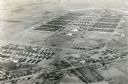
| Date: | 1945 |
|---|---|
| Description: | An aerial view of Truax Field, now also called Dane County Regional Airport. In addition to commercial flights, Truax Field is also home to the Army Nation... |

| Date: | 1947 |
|---|---|
| Description: | Aerial view of the Forest Products Laboratory. |
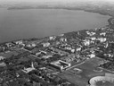
| Date: | 1947 |
|---|---|
| Description: | Aerial of University of Wisconsin-Madison campus with Camp Randall in the lower right corner and Lake Mendota, looking northeast to Maple Bluff. |

| Date: | 07 10 1949 |
|---|---|
| Description: | Aerial view of Minocqua showing the surrounding lakes. |

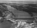
| Date: | 1950 |
|---|---|
| Description: | Aerial view of the Highway 21 bridge and Petenwell Dam on the Wisconsin River. |

| Date: | 1950 |
|---|---|
| Description: | Aerial view of the Wisconsin State Capitol building and surrounding Madison area. Lake Monona is in the background. |
| Date: | 1950 |
|---|---|
| Description: | Aerial view of a hydroelectric power plant owned by Northern States Power Company located on the Chippewa River. A highway bridge and a railroad bridge spa... |
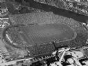
| Date: | 1952 |
|---|---|
| Description: | Aerial view of City Stadium, former home of the Green Bay Packers from 1925 to 1956. Currently it is the home of the Green Bay East High School football te... |
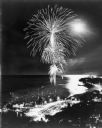
| Date: | 07 1973 |
|---|---|
| Description: | Aerial view of fireworks over Lake Michigan. Boats are moored in the harbor for a good view. |
If you didn't find the material you searched for, our Library Reference Staff can help.
Call our reference desk at 608-264-6535 or email us at:
