Search: War
Filter: Categories of Wisconsin Historical Images
Filter: Subject of landforms
Search: War
Filter: Categories of Wisconsin Historical Images
Filter: Subject of landforms

| Date: | 1740 |
|---|---|
| Description: | Engraved and hand-colored map of the Iberian peninsula as a theater of war during the War of the Spanish Succession (1701-1714). The map is dedicated to Ki... |
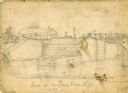
| Date: | 1856 |
|---|---|
| Description: | An original illustration of the lock at Rexford Flats. |

| Date: | 1864 |
|---|---|
| Description: | Fort Crawford was decommissioned in 1856, having outlived its usefulness as a frontier post. During the Civil War, however, it functioned as a military ho... |
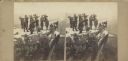
| Date: | 1864 |
|---|---|
| Description: | Albumen stereograph of the Union Army brass band posed and playing atop Lookout Point. The Tennessee River is in the background. |

| Date: | 1941 |
|---|---|
| Description: | Official highway map of Wisconsin, "the playground of the Midwest," showing the state transportation network prior to World War II. |
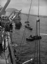
| Date: | |
|---|---|
| Description: | Wounded soldiers are being loaded onto a hospital ship in Iwo Jima. |

| Date: | 1862 |
|---|---|
| Description: | This map of the southeastern United States shows cities and towns, rail lines, and geographic features such as rivers, mountains, lakes, and swamps. |
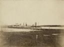
| Date: | 08 11 1943 |
|---|---|
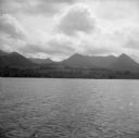
| Description: | A view of Milne Bay, New Guinea (present day Papua New Guinea), from the sea. A ship can be seen on the right, at the shoreline. |

| Date: | 1944 |
|---|---|
| Description: | An International K-5 truck and an M-2-4 truck used by the Seabees are driving along a dirt road built over a body of water. |

| Date: | 1952 |
|---|---|
| Description: | Typewritten note on Royal Hawaiian stationery reads: "Royal Hawaiian, Honolulu, Hawaii, U.S.A. Esther Van Wagoner Tufty, Washington D.C. war correspondent ... |

| Date: | 1915 |
|---|---|
| Description: | View looking down at an Austrian fortress officer lying in the grass at the crest of a ridge line, using it as an observation post while looking for the en... |
| Date: | |
|---|---|
| Description: | A halftone lithograph of the Battle of Grand Gulf, Mississippi. |

| Date: | 08 1957 |
|---|---|
| Description: | A Red Crescent doctor is holding an Algerian refugee child who survived a French air attack that killed eighteen people. Behind them is a shepherd's daught... |

| Date: | |
|---|---|
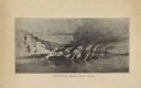
| Description: | A large lithograph showing the landscape, camps and bombardment. |

| Date: | 1925 |
|---|---|
| Description: | Aerial view of the site of the Confederate surrender in 1865. |
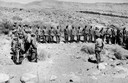
| Date: | 02 03 1944 |
|---|---|
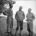
| Description: | Wisconsin artillery officers helping direct the shelling of the Japanese on Saidor's west flank (beyond the point in the background). The officers are, (le... |
| Date: | |
|---|---|
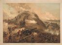
| Description: | "Capture of Fort Fisher." A color lithograph published by L. Prang & Co., Boston. |
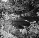
| Date: | 10 24 1943 |
|---|---|
| Description: | Robert Doyle's caption for Image ID: 99742 says it best, "The ol' swimmin' hole, South Pacific style. Every afternoon it is filled with shouting soldiers i... |
| Date: | 1863 |
|---|---|
| Description: | View from shoreline of the side-wheel steamship "Thomas Powell," probably in southern waters. Industrial buildings are in the background. |
If you didn't find the material you searched for, our Library Reference Staff can help.
Call our reference desk at 608-264-6535 or email us at: