 Search: War
Filter: Categories of Wisconsin Historical Images
Filter: County of Brown
Search: War
Filter: Categories of Wisconsin Historical Images
Filter: County of Brown
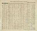
| Date: | 02 01 1864 |
|---|---|
| Description: | List of Civil War draft-dodgers issued by the Provost Marshal's office, Fifth District of Wisconsin. |
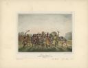
| Date: | 1842 |
|---|---|
| Description: | Menominee war dance, as depicted by Francois, Comte de Castelnau, a French naturalist and diplomat who visited Green Bay, Wisconsin about 1838. This detail... |
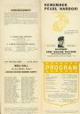
| Date: | 12 07 1942 |
|---|---|
| Description: | A souvenir program entitled "Remember Pearl Harbor!" for an event at Columbus Auditorium in Green Bay. The program includes roll call of the Earl Wallen Pl... |

| Date: | 1960 |
|---|---|
| Description: | This map is a facsimile of a 1829 map and shows private land claims, landowners within military reserve boundaries, sawmill, Fort Howard, public barns, bri... |

| Date: | 1914 |
|---|---|
| Description: | This map is a photostat copy from the original 1829 map in the War Department. The map shows location of Fort Howard, lots, land claims of Jacques Porlier ... |

| Date: | 1842 |
|---|---|
| Description: | This hand-colored lithograph of the second Fort Howard, with Indians canoeing on the Fox River, shows the hospital built 1834-1835 outside the stockade on ... |

| Date: | 1896 |
|---|---|
| Description: | Portraits of the members of the Samuel Harrison Post No. 91 of De Pere, Wisconsin from 1883-1896. |
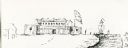
| Date: | |
|---|---|
| Description: | View of a fort with fortified walls and a flag flying from the fort. A river runs on the right of the image. A boat with sails floats on the river. Sold... |

| Date: | 04 11 1940 |
|---|---|
| Description: | This blue line print map shows survey monument markers by type and industrial buildings and covers part of the lower Fox River and East River. The map incl... |

| Date: | 1900 |
|---|---|
| Description: | This photocopied map shows private claim owners, buildings, and land use in 1818. Insets show Fort Howard and the caption reads: "A view of the Fox River ... |

| Date: | 1900 |
|---|---|
| Description: | This photostat of a manuscript map originally drawn in 1829 shows landownership, buildings, including Fort Howard and U.S. sawmill, swamps, public barns an... |
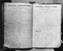
| Date: | 08 1871 |
|---|---|
| Description: | Caption reads: "Photocopy of the hotel register at the De Pere House De Pere Wis from Friday August 4 to Tuesday August 8 1871. Among names to be noted are... |
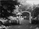
| Date: | 1963 |
|---|---|
| Description: | A rose garden with a trellis on the estate of Albert C. Neufeld at 204 West Whitney. |
If you didn't find the material you searched for, our Library Reference Staff can help.
Call our reference desk at 608-264-6535 or email us at: