 Search: War
Filter: Categories of Wisconsin Historical Images
Filter: Community of New Orleans
Search: War
Filter: Categories of Wisconsin Historical Images
Filter: Community of New Orleans

| Date: | |
|---|---|
| Description: | Waist-up carte-de-visite portrait of Lieutenant Issac N. Earl, Company D, 4th Wisconsin Cavalry. |
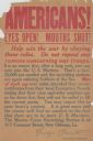
| Date: | 1917 |
|---|---|
| Description: | Recruitment poster for the U.S. Marines. Poster text reads: "Americans! Eyes Open! Mouths Shut! Help win the war by obeying these rules. Do not repeat any ... |

| Date: | |
|---|---|
| Description: | Full-length carte-de-visite portrait of George W. Honey, F & S, 4th Wisconsin Cavalry, standing, wearing clergy dress and holding a bible. |

| Date: | 1985 |
|---|---|
| Description: | Painting depicting the Battle of New Orleans, fought on 8 January 1815. In the upper corner of the painting Major General Andrew Jackson is shown at the to... |
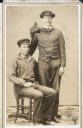
| Date: | |
|---|---|
| Description: | Seated carte-de-visite portrait of Private Henry C. Stafford, Company I, 4th Wisconsin Cavalry, and, standing on his left side, 1st Lieutenant Issac N. Ear... |
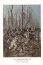
| Date: | 1982 |
|---|---|
| Description: | "The painting shows the Choctaws and a mixed group of Major Daquin's Battalion of Free Men of Color. The latter were mostly attired in civilian clothes bec... |

| Date: | 01 10 1942 |
|---|---|
| Description: | S.S. Robert M. La Follette splashing into the Industrial Canal at its launch. |
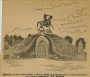
| Date: | |
|---|---|
| Description: | Drawing of a monument to General Albert Sydney Johnston, which was erected by Association of the Army of Tennessee in the St. Louis Cemetery in New Orleans... |

| Date: | 1759 |
|---|---|
| Description: | Map of New Orleans at the start of the French & Indian War, including two inset maps entitled "The Course of the Mississipi River from Bayagoulas to the Se... |

| Date: | 1769 |
|---|---|
| Description: | Map of New Orleans at the start of the French & Indian War, including two inset maps of the Mississippi River Delta and Fort la Balise. It shows streets, r... |
If you didn't find the material you searched for, our Library Reference Staff can help.
Call our reference desk at 608-264-6535 or email us at: