 Search: War
Filter: Categories of Wisconsin Historical Images
Filter: Creator Name of Cóvens et Mortier
Search: War
Filter: Categories of Wisconsin Historical Images
Filter: Creator Name of Cóvens et Mortier
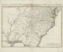
| Date: | 1758 |
|---|---|
| Description: | Regional map of south eastern America, based largely on D'Anville's map of North America in 1755. It shows the borders, regions, cities and towns, Native A... |
If you didn't find the material you searched for, our Library Reference Staff can help.
Call our reference desk at 608-264-6535 or email us at: