 Search: Texaco
Filter: Categories of Wisconsin Historical Images
Search: Texaco
Filter: Categories of Wisconsin Historical Images
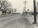
| Date: | 01 06 1938 |
|---|---|
| Description: | South Park Street (Hwy 12 & 14 & 18) looking south from the intersection at Midland Street. On the left across the street is Southside Pharmacy at 1123 Sou... |

| Date: | 1962 |
|---|---|
| Description: | This colored road map shows roads in Wisconsin as well as portions of nearby states. The map is organized such that a single map of Wisconsin is divided on... |

| Date: | 1971 |
|---|---|
| Description: | This colored map displays Wisconsin and bordering areas of Iowa, Minnesota, and Michigan. There is color-coding on the map to indicate National Forests, an... |

| Date: | 1973 |
|---|---|
| Description: | This colored map displays Wisconsin and bordering areas of Iowa, Minnesota, and Michigan. There is color-coding on the map to indicate National Forests, a... |
If you didn't find the material you searched for, our Library Reference Staff can help.
Call our reference desk at 608-264-6535 or email us at: