Search: Taylor
Filter: Categories of Wisconsin Historical Images
Filter: County of Taylor
Search: Taylor
Filter: Categories of Wisconsin Historical Images
Filter: County of Taylor

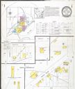
| Date: | 1909 |
|---|---|
| Description: | This 1909 map of Taylor County, Wisconsin, shows the township and range grid, towns, sections, cities and villages, settlers houses, schools, churches, saw... |

| Date: | 1914 |
|---|---|
| Description: | Exterior view of the Taylor Courthouse featuring a cupola with clocks. Caption reads: "County Courthouse, Medford, Wis." |

| Date: | |
|---|---|
| Description: | This map of Taylor County, Wisconsin, shows soil types, the township and range grid, sections, settlers houses, schools, churches, saw mills, tanneries, ro... |

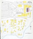
| Date: | 1940 |
|---|---|
| Description: | This map of Taylor County, Wisconsin, shows the township and range grid, towns, sections, cities and villages, railroads, roads, creameries and cheese fact... |

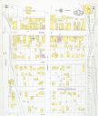
| Date: | 1887 |
|---|---|
| Description: | This 1887 map of Taylor County, Wisconsin, shows the township and range system, sections, railroads, vacant Wisconsin Central Railroad land, land sold by t... |
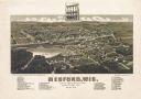
| Date: | 1885 |
|---|---|
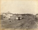
| Description: | Bird's-eye map of Medford, before the great fire of May 28, 1885. |

| Date: | 1930 |
|---|---|
| Description: | This map shows communities, state roads, county roads, railroads, lakes and rivers in the county. Areas marked in red are lands tax deeded to the county. |

| Date: | 1960 |
|---|---|
| Description: | This manuscript map of Taylor County, Wisconsin, shows the township and range grid, lakes and streams, "Chippewa trails, Indian trails" Indian villages and... |
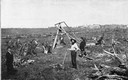
| Date: | 09 03 1895 |
|---|---|
| Description: | Clearing stumps with a stump machine on the farm of Christopher Paustenbach, three miles east of Medford, Taylor County. |

| Date: | 1887 |
|---|---|
| Description: | This 1896 map shows the township and range system, sections, cities and villages, railroads, roads, vacant land and land sold by the Wisconsin Central Rail... |

| Date: | 1895 |
|---|---|
| Description: | Promotional card advertising the school house in Rib Lake. The caption reads, "SCHOOL HOUSE, RIB LAKE, TAYLOR COUNTY, WIS. -In all the towns of Price and T... |
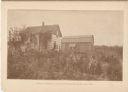
| Date: | 1895 |
|---|---|
| Description: | Promotional card displaying John Riemer and a women in front his home.
The caption reads, "Home of John Riemer, 3.75 miles from Stetsonville, Taylor C... |
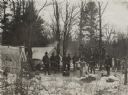
| Date: | 1909 |
|---|---|
| Description: | View of a hunting camp with the hunters assembled with their rifles in front of deer carcasses. |

| Date: | 1895 |
|---|---|
| Description: | A promotional card displaying a populated village street near a lake in Northern Wisconsin. The caption bellow the photography reads: "RIB LAKE, TAYLOR C... |
If you didn't find the material you searched for, our Library Reference Staff can help.
Call our reference desk at 608-264-6535 or email us at: