 Search: Lapham
Search: papers
Filter: Categories of Wisconsin Historical Images
Filter: County of Dane
Search: Lapham
Search: papers
Filter: Categories of Wisconsin Historical Images
Filter: County of Dane

| Date: | 11 1953 |
|---|---|
| Description: | Four Lapham School students and an adult eating ice cream from a paper cup at the end of a tour of Bowman Farm Dairy on Fish Hatchery Road. |

| Date: | 1864 |
|---|---|
| Description: | This map is pen and watercolor on paper and shows profile and geological formation of Blue Mound and location of Arnold’s Hotel and Brigham Lead Mines. |

| Date: | 1907 |
|---|---|
| Description: | The Yahara River Parkway, with the old Lapham School at 1436 East Dayton Street at North Thornton visible on the righthand side. |
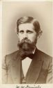
| Date: | 1872 |
|---|---|
| Description: | Carte-de-visite portrait of Professor W.W. Daniels, University of Wisconsin geologist. Daniels worked as one of Increase Lapham's assistants during the Wis... |
If you didn't find the material you searched for, our Library Reference Staff can help.
Call our reference desk at 608-264-6535 or email us at: