Search: LIGHTHOUSES
| Community: | Bayfield |
|---|---|
| County: | Bayfield |
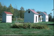
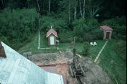
| Historic Name: | Raspberry Island Light Outbuilding |
| Reference Number: | 243084 |
| Community: | Bayfield |
|---|---|
| County: | Bayfield |
| Historic Name: | Raspberry Island Light Outbuilding |
| Reference Number: | 243085 |
| Community: | Bayfield |
|---|---|
| County: | Bayfield |
| Historic Name: | Raspberry Island Light Outbuilding |
| Reference Number: | 243086 |

| Date: | 1848 |
|---|---|
| Description: | Wisconsin became the thirtieth state in 1848. Drawn that same year, this map shows township lines, roads, villages, mills, railroads, prairies, swamps, can... |

| Date: | 1896 |
|---|---|
| Description: | This 1896 map of Racine and Kenosha counties, Wisconsin, shows the township and range grid, towns, sections, cities, villages and post offices, roads, rail... |

| Date: | 1905 |
|---|---|
| Description: | This early 20th century map of Door County, Wisconsin, shows the township and range grid, towns, sections, cities and villages, landownership and acreages,... |
| Date: | |
|---|---|
| Description: | Lighthouse and buildings on Devil's Island of the Apostle Islands. |
| Community: | Russell |
|---|---|
| County: | Bayfield |
| Historic Name: | OUTBUILDING |
| Reference Number: | 12557 |

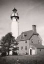
| Date: | 1967 |
|---|---|
| Description: | Ground view of the Cana Island Lighthouse. |
| Community: | Bayfield |
|---|---|
| County: | Bayfield |
| Historic Name: | Raspberry Island Light Machine Building |
| Reference Number: | 243080 |

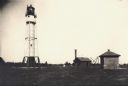
| Date: | 1905 |
|---|---|
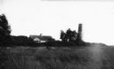
| Description: | Long Tail Lighthouse and surrounding buildings. |
| Date: | 1950 |
|---|---|
| Description: | Lighthouse on Outer Island of the Apostle Islands. |
| Community: | Russell |
|---|---|
| County: | Bayfield |
| Historic Name: | OUTBUILDING |
| Reference Number: | 12558 |
| Community: | Bayfield |
|---|---|
| County: | Bayfield |
| Historic Name: | Raspberry Island Light Outbuilding |
| Reference Number: | 243082 |
| Community: | La Pointe |
|---|---|
| County: | Ashland |
| Historic Name: | Michigan Island Light Outhouse |
| Reference Number: | 243092 |
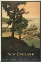
| Date: | 1947 |
|---|---|
| Description: | An original lithograph promoting New York Central Lines railway and the area of New England, deemed "America's Historic Summerland" in the poster. Featurin... |

| Date: | 1912 |
|---|---|
| Description: | This map from the U.S. General Land Office shows railroads, counties, cities and villages, rivers, lakes, U.S. Land Offices, Indian reservations, military ... |

| Date: | 1898 |
|---|---|
| Description: | This 1898 map of Ashland County, Wisconsin, shows the township and range grid, towns, sections, cities and villages, landownership, roads, railroads, swamp... |
| Community: | Bayfield |
|---|---|
| County: | Bayfield |
| Historic Name: | Sand Island Light Outhouse |
| Reference Number: | 243076 |
If you didn't find the material you searched for, our Library Reference Staff can help.
Call our reference desk at 608-264-6535 or email us at: