 Search: LIGHTHOUSES
Filter: Year of 1900-1999
Filter: Year of 1910-1919
Filter: Subject of water
Search: LIGHTHOUSES
Filter: Year of 1900-1999
Filter: Year of 1910-1919
Filter: Subject of water

| Date: | 1911 |
|---|---|
| Description: | This map of Duluth and Superior shows street car routes, railroads, ferries, some points of interest, and lighthouses. The bottom left of the map reads: "C... |

| Date: | 1912 |
|---|---|
| Description: | This map from the U.S. General Land Office shows railroads, counties, cities and villages, rivers, lakes, U.S. Land Offices, Indian reservations, military ... |

| Date: | 1916 |
|---|---|
| Description: | This Wisconsin Conservation Commission map from 1916 shows Peninsula State Park in the Town of Gibraltar, Door County, Wisconsin. Depicted are open and pla... |

| Date: | 1916 |
|---|---|
| Description: | This version of a 1916 Wisconsin Conservation Commission map shows Peninsula State Park in the Town of Gibraltar, Door County, Wisconsin. Depicted are open... |

| Date: | 1915 |
|---|---|
| Description: | This map of Door County, Wisconsin, from the early 20th century shows roads, schools, churches, creameries and cheese factories, orchards, docks, quarries,... |
| Date: | 1915 |
|---|---|
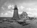
| Description: | Colorized view of the Sherwood Point Lighthouse. Caption reads: "Sherwood Point Light House, Sturgeon Bay, Wis." |

| Date: | 1915 |
|---|---|
| Description: | View of the Sturgeon Bay ship canal. Caption reads: "Sturgeon Bay Ship Canal." |
| Date: | 1915 |
|---|---|
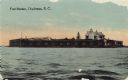
| Description: | View across water toward Fort Sumter. Caption reads: "Fort Sumter, Charleston, S. C." |

| Date: | 1913 |
|---|---|
| Description: | View of the canal. Caption reads: "The Canal, Stugeon[sic] Bay, Wis." |
| Date: | 1912 |
|---|---|
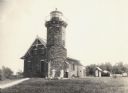
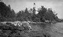
| Description: | The Cana Island lighthouse and keeper's house with the rocky shore in the foreground. |
| Date: | 1912 |
|---|---|
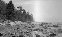
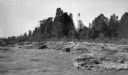
| Description: | Cana Island lighthouse is seen in the far distance across the stony shoreline along Lake Michigan. |
| Date: | 1910 |
|---|---|
| Description: | View of the main pier and harbor lighthouse from the Lake Michigan shoreline. Caption reads: "Bay and Pier, Racine, Wis." |
| Date: | 1915 |
|---|---|
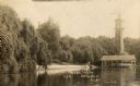
| Description: | Sand Island Lighthouse on Apostle Island, Lake Superior. Lighthouse keeper and family are posing in the front of the building. |
| Date: | 1918 |
|---|---|
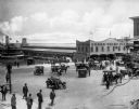
| Description: | Elevated view of the Cedar Point Pier. Pedestrians, automobiles and horse-drawn vehicles are in the foreground. |
| Date: | 1910 |
|---|---|
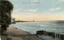
| Description: | View of the north shore of Delavan Lake with a lighthouse in the background. Also known as "Red Top" and "L.P. Sutter's." Caption reads: North Shore, Delav... |
| Date: | 1915 |
|---|---|
| Description: | The Baileys Harbor Light as seen from the water. The lighthouse, with a tapered cylindrical stone base, birdcage lantern, and copper dome, was deactivated ... |
| Date: | 1918 |
|---|---|
| Description: | View across rocks toward the Mount Desert Rock granite lighthouse, established in 1830 and automated in 1977, located thirty miles out to sea on a treeless... |

| Date: | 1915 |
|---|---|
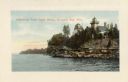
| Description: | Birch and evergreen trees line the rocky shore of Toft Point, with Cana Island and its lighthouse in the background. |
| Date: | 1910 |
|---|---|
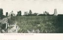
| Description: | Caption reads: "Old Light House at Long Tail Point, Green Bay, Wis." Built in 1859. A marshy area is in the foreground, and a long pier leads to the new li... |
| Date: | 1915 |
|---|---|
| Description: | Ferdinand Leonard (Fedy) Hotz, far left, sisters Helen, left, and Alice, sit with Thomas Toft on the rocky shore near the Baileys Harbor lighthouse. A rowb... |
If you didn't find the material you searched for, our Library Reference Staff can help.
Call our reference desk at 608-264-6535 or email us at: