 Search: LIGHTHOUSES
Filter: Year of 1900-1999
Filter: Subject of transportation
Search: LIGHTHOUSES
Filter: Year of 1900-1999
Filter: Subject of transportation

| Date: | 1946 |
|---|---|
| Description: | Map of Kewaunee County, Wisconsin, shows towns, cities and villages, roads and highways, railroads, schools, lighthouses, place names, town divisions, comm... |

| Date: | 1911 |
|---|---|
| Description: | This map of Duluth and Superior shows street car routes, railroads, ferries, some points of interest, and lighthouses. The bottom left of the map reads: "C... |

| Date: | 1938 |
|---|---|
| Description: | This map shows roads, parks, golf courses, airports, beaches, docks and harbors, lighthouses, and buoys within Winnebago County and parts of Waushara, Calu... |

| Date: | 1905 |
|---|---|
| Description: | This early 20th century map of Door County, Wisconsin, shows the township and range grid, towns, sections, cities and villages, landownership and acreages,... |
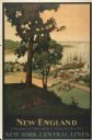
| Date: | 1947 |
|---|---|
| Description: | An original lithograph promoting New York Central Lines railway and the area of New England, deemed "America's Historic Summerland" in the poster. Featurin... |

| Date: | 1916 |
|---|---|
| Description: | This Wisconsin Conservation Commission map from 1916 shows Peninsula State Park in the Town of Gibraltar, Door County, Wisconsin. Depicted are open and pla... |

| Date: | 1916 |
|---|---|
| Description: | This version of a 1916 Wisconsin Conservation Commission map shows Peninsula State Park in the Town of Gibraltar, Door County, Wisconsin. Depicted are open... |

| Date: | 1915 |
|---|---|
| Description: | This map of Door County, Wisconsin, from the early 20th century shows roads, schools, churches, creameries and cheese factories, orchards, docks, quarries,... |
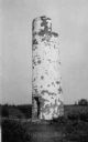
| Date: | 1910 |
|---|---|
| Description: | View of the remnants of the Minnesota Point Lighthouse. Faint caption at bottom reads: "Lighthouse". |

| Date: | 1915 |
|---|---|
| Description: | View of the Sturgeon Bay ship canal. Caption reads: "Sturgeon Bay Ship Canal." |

| Date: | 1913 |
|---|---|
| Description: | View of the canal. Caption reads: "The Canal, Stugeon[sic] Bay, Wis." |
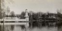
| Date: | 1935 |
|---|---|
| Description: | Lake Okauchee lighthouse. Buildings are in the background along a tree-covered shoreline. |

| Date: | 1960 |
|---|---|
| Description: | This mid-20th century tourist brochure for Bayfield County, Wisconsin, includes a map of the county showing towns, cities and villages, highways and roads,... |

| Date: | 1967 |
|---|---|
| Description: | This tourist brochure for Bayfield County, Wisconsin, from 1967 includes a map of the county showing towns, cities and villages, highways and roads, railro... |
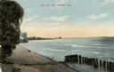
| Date: | 1910 |
|---|---|
| Description: | View of the main pier and harbor lighthouse from the Lake Michigan shoreline. Caption reads: "Bay and Pier, Racine, Wis." |

| Date: | 12 10 1957 |
|---|---|
| Description: | View of harbor with pilings in the right foreground. There is a lighthouse on breakwaters in the distance. |

| Date: | 1953 |
|---|---|
| Description: | View across water towards the Sturgeon Bay Canal Lighthouse, with a group of people in a motorboat in the foreground. |
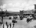
| Date: | 1918 |
|---|---|
| Description: | Elevated view of the Cedar Point Pier. Pedestrians, automobiles and horse-drawn vehicles are in the foreground. |

| Date: | 1966 |
|---|---|
| Description: | A colored map depiction of Door County, Wisconsin, with pictorial highlights, titled: "Door County — Wisconsin's Air Conditioned Peninsula Playground." |

| Date: | 12 22 1908 |
|---|---|
| Description: | Text reads: "Views of Racine, Wis." A collage of 12 postcards with views of buildings, landmarks and ships. |
If you didn't find the material you searched for, our Library Reference Staff can help.
Call our reference desk at 608-264-6535 or email us at: