 Search: LIGHTHOUSES
Filter: Subject of transportation
Search: LIGHTHOUSES
Filter: Subject of transportation
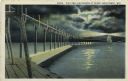
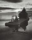
| Date: | 1927 |
|---|---|
| Description: | Hand-colored postcard view of a pier and lighthouse at night. The moon shines through clouds, and light shines in two directions from the beacon on top of ... |

| Date: | 1891 |
|---|---|
| Description: | Photograph of a painting by May Conniff Frost showing the tugboat Record of the Inman Line pulling a lake schooner through rough waters into Superio... |
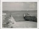
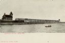
| Date: | 07 27 1960 |
|---|---|
| Description: | View from shoreline at Port Washington south of two ramps within a breakwater. There is a lighthouse in the background. Boats are along a pier on the right... |

| Date: | |
|---|---|
| Description: | Aerial view of harbor. In the foreground is a lighthouse and breakwaters. Bridges cross the harbor, and there are factory and industrial buildings near the... |

| Date: | 1905 |
|---|---|
| Description: | This map shows railroads, towns, lights, lights to be established, fog signals, light-vessels, lighted buoys, light-house depots, and light-house reservati... |

| Date: | 1857 |
|---|---|
| Description: | This map shows lot and block numbers, streets, railroad depots, locks, bridges, dams, canals, U.S. light house, college grounds, a steam boat landing, and ... |
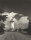
| Date: | 1954 |
|---|---|
| Description: | View down road towards the Fond du Lac lighthouse, built in 1933. There are cumulus clouds in the sky, and pine trees are lining the shore. |
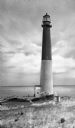
| Date: | |
|---|---|
| Description: | Barnegat Lighthouse was built in 1854 by the U.S. government. Oil-powered lights were originally installed in 1856 but were replaced by electric lights in ... |
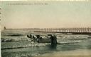
| Date: | 1908 |
|---|---|
| Description: | Group of men on a life saving crew launching a rowboat into Lake Michigan. A long pier with a lighthouse at the end bisects the horizon. Caption reads: "Li... |

| Date: | 1906 |
|---|---|
| Description: | Hand-colored postcard view of the Sturgeon Bay ship canal from the bay toward shore. A sailboat is on the left and a lighthouse is on shore on the right. C... |
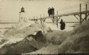
| Date: | 1910 |
|---|---|
| Description: | Postcard view of three men on an elevated walk on an icy pier near the shoreline. A women and young boy stand on the pier below the walk. There is a lighth... |

| Date: | 1927 |
|---|---|
| Description: | A switchback path leading to Cap Carbon and the lighthouse perched near the summit of the peninsula. The lighthouse is built on top of a giant rock that pr... |

| Date: | 01 08 1958 |
|---|---|
| Description: | Elevated view from 8th Street Bridge over the Manitowoc River towards Lake Michigan. There is a lighthouse in the distance. Ice is floating on the water. A... |

| Date: | 1795 |
|---|---|
| Description: | Map of South Carolina showing the precincts, cities, towns, Native American villages (marked with a triangle), courthouses, roads, mountains, swamps, islan... |
| Date: | 1916 |
|---|---|
| Description: | Tinted postcard of the lighthouse and a light tower at the end of a pier. A small boat with two passengers is on the water. This would be the Racine North ... |
| Date: | 03 1969 |
|---|---|
| Description: | The Sturgeon Bay Ship Canal Pierhead Lighthouse silhouetted against the sun shining through the clouds. Snow covers the pier, and ice is floating on the la... |
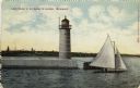
| Date: | 1910 |
|---|---|
| Description: | Hand-colored postcard view of a pier and lighthouse at the entrance to Milwaukee's harbor. Two people sail in a small boat to the right of the lighthouse, ... |

| Date: | 01 07 1958 |
|---|---|
| Description: | View from the Second Street bridge over the icy Ahnapee River towards Lake Michigan. A lighthouse is at the end of a jetty in the far background. Boats are... |

| Date: | 1905 |
|---|---|
| Description: | This map shows railroads, towns, lights, lights to be established, fog signals, light-vessels, lighted buoys, light-house depots, and light-house reservati... |

| Date: | 1940 |
|---|---|
| Description: | A log gate and log-framed sign mark the entrance to the Twin River (Rawley) Point lighthouse. The keeper's house is next to the light and has a turret and ... |
If you didn't find the material you searched for, our Library Reference Staff can help.
Call our reference desk at 608-264-6535 or email us at: