Search: LIGHTHOUSES
Filter: Subject of cities and towns
Filter: Year of 1900-1999
Search: LIGHTHOUSES
Filter: Subject of cities and towns
Filter: Year of 1900-1999

| Date: | 1931 |
|---|---|
| Description: | This U.S. Geological Survey map of Wisconsin shows counties, cities and villages, lighthouses, Indian reservations, military reservations, and bird and gam... |

| Date: | 1946 |
|---|---|
| Description: | Map of Kewaunee County, Wisconsin, shows towns, cities and villages, roads and highways, railroads, schools, lighthouses, place names, town divisions, comm... |

| Date: | 1911 |
|---|---|
| Description: | This map of Duluth and Superior shows street car routes, railroads, ferries, some points of interest, and lighthouses. The bottom left of the map reads: "C... |

| Date: | 1905 |
|---|---|
| Description: | This early 20th century map of Door County, Wisconsin, shows the township and range grid, towns, sections, cities and villages, landownership and acreages,... |

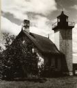
| Date: | 1905 |
|---|---|
| Description: | Long Tail Lighthouse and surrounding buildings. |

| Date: | 1912 |
|---|---|
| Description: | This map from the U.S. General Land Office shows railroads, counties, cities and villages, rivers, lakes, U.S. Land Offices, Indian reservations, military ... |

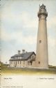
| Date: | 1900 |
|---|---|
| Description: | A view of the lighthouse and dock office at Peshtigo Harbor. |

| Date: | 1915 |
|---|---|
| Description: | This map of Door County, Wisconsin, from the early 20th century shows roads, schools, churches, creameries and cheese factories, orchards, docks, quarries,... |

| Date: | 1915 |
|---|---|
| Description: | View of the Sturgeon Bay ship canal. Caption reads: "Sturgeon Bay Ship Canal." |

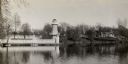
| Date: | 1913 |
|---|---|
| Description: | View of the canal. Caption reads: "The Canal, Stugeon[sic] Bay, Wis." |
| Date: | 1935 |
|---|---|
| Description: | Lake Okauchee lighthouse. Buildings are in the background along a tree-covered shoreline. |

| Date: | 1960 |
|---|---|
| Description: | This mid-20th century tourist brochure for Bayfield County, Wisconsin, includes a map of the county showing towns, cities and villages, highways and roads,... |
| Date: | 1940 |
|---|---|
| Description: | A rear view of the Eagle Harbor Lighthouse at Peninsula State Park. |
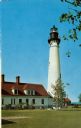
| Date: | 1952 |
|---|---|
| Description: | Text on front reads: "Racine, Wis.", "North Point Lighthouse". This is actually the Wind Point Lighthouse on Wind Point, located on the north end of Racine... |

| Date: | 1967 |
|---|---|
| Description: | This tourist brochure for Bayfield County, Wisconsin, from 1967 includes a map of the county showing towns, cities and villages, highways and roads, railro... |
| Date: | 1920 |
|---|---|
| Description: | View across water toward the lighthouse. Caption reads: "Grassy Island Lighthouse, Green Bay, Wis." |
| Date: | 1910 |
|---|---|
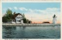
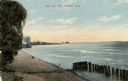
| Description: | View of the main pier and harbor lighthouse from the Lake Michigan shoreline. Caption reads: "Bay and Pier, Racine, Wis." |

| Date: | 1937 |
|---|---|
| Description: | Lighthouse built by State Senator William Bray of Oshkosh, on a point where the Fox River empties into Lake Winnebago. |

| Date: | 1953 |
|---|---|
| Description: | View across water towards the Sturgeon Bay Canal Lighthouse, with a group of people in a motorboat in the foreground. |
If you didn't find the material you searched for, our Library Reference Staff can help.
Call our reference desk at 608-264-6535 or email us at: