Search: LIGHTHOUSES
Filter: Subject of cities and towns
Filter: Subject of michigan, lake
Search: LIGHTHOUSES
Filter: Subject of cities and towns
Filter: Subject of michigan, lake

| Date: | |
|---|---|
| Description: | View toward the two lighthouses on either side of Kenosha Harbor. The lighthouse on the right has an elevated walkway to the entrance. Caption reads: "Ligh... |

| Date: | 1931 |
|---|---|
| Description: | This U.S. Geological Survey map of Wisconsin shows counties, cities and villages, lighthouses, Indian reservations, military reservations, and bird and gam... |

| Date: | 1946 |
|---|---|
| Description: | Map of Kewaunee County, Wisconsin, shows towns, cities and villages, roads and highways, railroads, schools, lighthouses, place names, town divisions, comm... |

| Date: | 1848 |
|---|---|
| Description: | This map shows lighthouses on part of Lake Superior, Green Bay, Lake Michigan, Lake Huron, Lake St. Clair, Lake Erie, Lake Ontario, the St. Lawrence River,... |

| Date: | 1848 |
|---|---|
| Description: | Wisconsin became the thirtieth state in 1848. Drawn that same year, this map shows township lines, roads, villages, mills, railroads, prairies, swamps, can... |

| Date: | 1912 |
|---|---|
| Description: | This map from the U.S. General Land Office shows railroads, counties, cities and villages, rivers, lakes, U.S. Land Offices, Indian reservations, military ... |

| Date: | 1880 |
|---|---|
| Description: | Map of Wisconsin including the eastern portions on Minnesota, Iowa, northern Illinois, and the western most portion of Michigan’s Upper Peninsula, showing ... |
| Date: | |
|---|---|
| Description: | View of a U.S. lighthouse and Coast Guard station. |

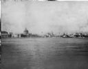
| Date: | 1856 |
|---|---|
| Description: | View of Manitowoc from the north side. |
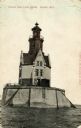
| Date: | |
|---|---|
| Description: | View of the Reef Lighthouse. Caption reads: "Racine Reef Light House, Racine, Wis." |

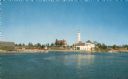
| Date: | 1915 |
|---|---|
| Description: | View of the Sturgeon Bay ship canal. Caption reads: "Sturgeon Bay Ship Canal." |

| Date: | 1913 |
|---|---|
| Description: | View of the canal. Caption reads: "The Canal, Stugeon[sic] Bay, Wis." |
| Date: | 1893 |
|---|---|
| Description: | View of the Columbian Exposition grounds from Lake Michigan. |

| Date: | 1896 |
|---|---|
| Description: | This hand-colored map shows counties, county seats, cities, towns, proposed and completed railroads, and U.S. Land Offices. Also included in the map are th... |
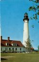
| Date: | 1952 |
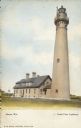
|---|---|
| Description: | Text on front reads: "Racine, Wis.", "North Point Lighthouse". This is actually the Wind Point Lighthouse on Wind Point, located on the north end of Racine... |
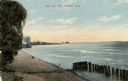
| Date: | 1910 |
|---|---|
| Description: | View of the main pier and harbor lighthouse from the Lake Michigan shoreline. Caption reads: "Bay and Pier, Racine, Wis." |

| Date: | |
|---|---|
| Description: | Illustration of view across water towards a lighthouse and surrounding buildings. Caption reads: "U.S. Light House, Kenosha, Wis." |
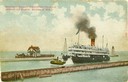
| Date: | |
|---|---|
| Description: | The screw passenger excursion vessel, "Christopher Columbus," being towed into the Milwaukee harbor past a breakwater. Milwaukee North Pier Inner Light in ... |

| Date: | 1953 |
|---|---|
| Description: | View across water towards the Sturgeon Bay Canal Lighthouse, with a group of people in a motorboat in the foreground. |
If you didn't find the material you searched for, our Library Reference Staff can help.
Call our reference desk at 608-264-6535 or email us at: