 Search: LIGHTHOUSES
Filter: Reproduction Rights of For Sale
Search: LIGHTHOUSES
Filter: Reproduction Rights of For Sale
| Date: | 1947 |
|---|---|
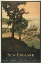
| Description: | An original lithograph promoting New York Central Lines railway and the area of New England, deemed "America's Historic Summerland" in the poster. Featurin... |

| Date: | 1912 |
|---|---|
| Description: | This map from the U.S. General Land Office shows railroads, counties, cities and villages, rivers, lakes, U.S. Land Offices, Indian reservations, military ... |

| Date: | 1898 |
|---|---|
| Description: | This 1898 map of Ashland County, Wisconsin, shows the township and range grid, towns, sections, cities and villages, landownership, roads, railroads, swamp... |
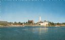
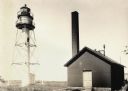
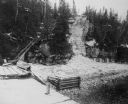
| Date: | |
|---|---|
| Description: | View of a U.S. lighthouse and Coast Guard station. |

| Date: | 1856 |
|---|---|
| Description: | View of Manitowoc from the north side. |
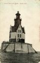
| Date: | |
|---|---|
| Description: | View of the Reef Lighthouse. Caption reads: "Racine Reef Light House, Racine, Wis." |

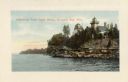
| Date: | 1900 |
|---|---|
| Description: | A view of the lighthouse and dock office at Peshtigo Harbor. |

| Date: | 1880 |
|---|---|
| Description: | Map of Wisconsin including the eastern portions on Minnesota, Iowa, northern Illinois, and the western most portion of Michigan’s Upper Peninsula, showing ... |

| Date: | 1916 |
|---|---|
| Description: | This Wisconsin Conservation Commission map from 1916 shows Peninsula State Park in the Town of Gibraltar, Door County, Wisconsin. Depicted are open and pla... |
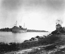
| Date: | |
|---|---|
| Description: | The screw passenger cruise vessel, "South American," in a channel. Shore and lighthouse in foreground. |
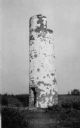
| Date: | 1910 |
|---|---|
| Description: | View of the remnants of the Minnesota Point Lighthouse. Faint caption at bottom reads: "Lighthouse". |
| Date: | 1915 |
|---|---|
| Description: | Colorized view of the Sherwood Point Lighthouse. Caption reads: "Sherwood Point Light House, Sturgeon Bay, Wis." |

| Date: | 1915 |
|---|---|
| Description: | View of the Sturgeon Bay ship canal. Caption reads: "Sturgeon Bay Ship Canal." |
| Date: | 1996 |
|---|---|
| Description: | Fjoloy Lighthouse on the coast of in Stavanger, Norway. |
| Date: | |
|---|---|
| Description: | La Pointe Light on Long Island (Apostle Islands), Chequamegon Bay, Lake Superior. |
| Date: | |
|---|---|
| Description: | The stairs and dock at the lighthouse on Rock Island. |
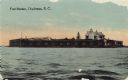
| Date: | 1915 |
|---|---|
| Description: | View across water toward Fort Sumter. Caption reads: "Fort Sumter, Charleston, S. C." |

| Date: | |
|---|---|
| Description: | View across water toward the Crabtree Ledge cast iron lighthouse, established in 1890 and discontinued in 1933. |

| Date: | |
|---|---|
| Description: | A rocky coast is populated with homes, hotels, and a lighthouse. |

| Date: | 1916 |
|---|---|
| Description: | This version of a 1916 Wisconsin Conservation Commission map shows Peninsula State Park in the Town of Gibraltar, Door County, Wisconsin. Depicted are open... |
If you didn't find the material you searched for, our Library Reference Staff can help.
Call our reference desk at 608-264-6535 or email us at: