 Search: LIGHTHOUSES
Filter: Reproduction Rights of For Sale
Search: LIGHTHOUSES
Filter: Reproduction Rights of For Sale

| Date: | 07 19 1854 |
|---|---|
| Description: | This map shows the shore in 1844, 1850, and 1852, the length of and proposed additions to the pier. Relief is shown by hachures and depths are shown by sou... |

| Date: | 1970 |
|---|---|
| Description: | This map shows roads, parks, swimming beaches, golf courses, yacht harbors, light houses, airports, public hunting grounds, waysides, schools, and fishing ... |

| Date: | |
|---|---|
| Description: | "Colortone" postcard view of the Wind Point Lighthouse, along with two other buildings. A fence surrounds the buildings, and in the distance a steamship is... |
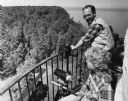
| Date: | 07 21 1985 |
|---|---|
| Description: | View of a man and a woman looking over a railing, with binoculars and a telescopic lens at hand. Caption reads: "Light keeper John Foote and researcher Lau... |

| Date: | 01 04 1862 |
|---|---|
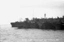
| Description: | Engraving of the city of Superior and Lake Superior, also depicting railroad piers, Minnesota Point, and the steamboat "Star". The engraving appears on a l... |
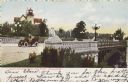
| Date: | 1905 |
|---|---|
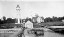
| Description: | South entrance; an open car with two people is crossing the bridge. Stone lions flank the bridge on each corner. A lighthouse is in the background. Caption... |
| Date: | |
|---|---|
| Description: | View across water toward the Spring Point Lighthouse, established in 1897 and automated in 1934. There is a small boat near the base of the lighthouse, and... |
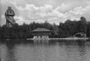
| Date: | |
|---|---|
| Description: | View across water towards the Mayor's summer home as seen from across Pine Lake. Children and adults are standing in front of the two-story dwelling. To th... |
| Date: | 1934 |
|---|---|
| Description: | View from water of Devil's Island lighthouse located above sandstone caves and arches in the Apostle Islands of Lake Superior. Caption reads: "Devil's Isla... |
| Date: | 1927 |
|---|---|
| Description: | View of the Plum Island rear range lighthouse from the end of the pier. The brick house was home to the lighthouse keeper and the first and second assistan... |

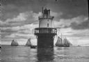
| Date: | 1908 |
|---|---|
| Description: | A detailed map of Michigan Island and Gull Island in the Apostle Islands group (T51N, R1W, 4 M) that shows sections, landowners, the Michigan Island Lighth... |
| Date: | 1927 |
|---|---|
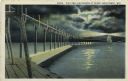
| Description: | Hand-colored postcard view of a pier and lighthouse at night. The moon shines through clouds, and light shines in two directions from the beacon on top of ... |

| Date: | 1891 |
|---|---|
| Description: | Photograph of a painting by May Conniff Frost showing the tugboat Record of the Inman Line pulling a lake schooner through rough waters into Superio... |
| Date: | 07 04 1947 |
|---|---|
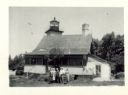
| Description: | Group of people standing in the yard in front of the lighthouse. The verso has this annotation: "'Eagle Light' Lighthouse, Peninsula Park, Fish Creek, Wi... |

| Date: | 01 09 1958 |
|---|---|
| Description: | Elevated view from bluff of the harbor towards the southeast. At the end of a jetty is a lighthouse on the left. The water is frozen along the shoreline. T... |
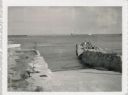
| Date: | 07 27 1960 |
|---|---|
| Description: | View from shoreline at Port Washington south of two ramps within a breakwater. There is a lighthouse in the background. Boats are along a pier on the right... |

| Date: | |
|---|---|
| Description: | Aerial view of harbor. In the foreground is a lighthouse and breakwaters. Bridges cross the harbor, and there are factory and industrial buildings near the... |

| Date: | 1905 |
|---|---|
| Description: | This map shows railroads, towns, lights, lights to be established, fog signals, light-vessels, lighted buoys, light-house depots, and light-house reservati... |

| Date: | 1900 |
|---|---|
| Description: | This blue line print map shows land use, cables, U.S.L.S.S. walk and clearing, and front and rear range lights on the Porte des Morts Passage. Tree types a... |

| Date: | 1857 |
|---|---|
| Description: | This map shows lot and block numbers, streets, railroad depots, locks, bridges, dams, canals, U.S. light house, college grounds, a steam boat landing, and ... |
If you didn't find the material you searched for, our Library Reference Staff can help.
Call our reference desk at 608-264-6535 or email us at: