 Search: LIGHTHOUSES
Filter: Reproduction Rights of For Sale
Filter: Subject of water
Filter: Creator Name of Unknown
Search: LIGHTHOUSES
Filter: Reproduction Rights of For Sale
Filter: Subject of water
Filter: Creator Name of Unknown

| Date: | 1946 |
|---|---|
| Description: | Map of Kewaunee County, Wisconsin, shows towns, cities and villages, roads and highways, railroads, schools, lighthouses, place names, town divisions, comm... |

| Date: | |
|---|---|
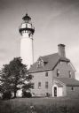
| Description: | Michigan Island Lighthouse, Apostle Islands, Lake Superior. |
| Date: | 1950 |
|---|---|
| Description: | Lighthouse on Outer Island of the Apostle Islands. |
| Date: | |
|---|---|
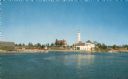
| Description: | View of a U.S. lighthouse and Coast Guard station. |

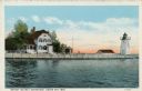
| Date: | 1900 |
|---|---|
| Description: | A view of the lighthouse and dock office at Peshtigo Harbor. |
| Date: | |
|---|---|
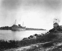
| Description: | The screw passenger cruise vessel, "South American," in a channel. Shore and lighthouse in foreground. |
| Date: | 1915 |
|---|---|
| Description: | Colorized view of the Sherwood Point Lighthouse. Caption reads: "Sherwood Point Light House, Sturgeon Bay, Wis." |
| Date: | 1915 |
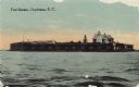
|---|---|
| Description: | View across water toward Fort Sumter. Caption reads: "Fort Sumter, Charleston, S. C." |

| Date: | |
|---|---|
| Description: | View across water toward the Crabtree Ledge cast iron lighthouse, established in 1890 and discontinued in 1933. |

| Date: | |
|---|---|
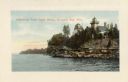
| Description: | A rocky coast is populated with homes, hotels, and a lighthouse. |

| Date: | 1913 |
|---|---|
| Description: | View of the canal. Caption reads: "The Canal, Stugeon[sic] Bay, Wis." |

| Date: | 1909 |
|---|---|
| Description: | View across water towards the steep shoreline and lighthouse at Eagle Harbor. |

| Date: | 1960 |
|---|---|
| Description: | This mid-20th century tourist brochure for Bayfield County, Wisconsin, includes a map of the county showing towns, cities and villages, highways and roads,... |

| Date: | 1967 |
|---|---|
| Description: | This tourist brochure for Bayfield County, Wisconsin, from 1967 includes a map of the county showing towns, cities and villages, highways and roads, railro... |
| Date: | 1920 |
|---|---|
| Description: | View across water toward the lighthouse. Caption reads: "Grassy Island Lighthouse, Green Bay, Wis." |
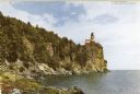
| Date: | |
|---|---|
| Description: | View along rocky shoreline toward the lighthouse. Caption reads: "Split Rock Lighthouse on north shore of Lake Superior." |
| Date: | 1910 |
|---|---|
| Description: | View of the main pier and harbor lighthouse from the Lake Michigan shoreline. Caption reads: "Bay and Pier, Racine, Wis." |

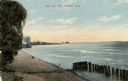
| Date: | 1890 |
|---|---|
| Description: | View from the shore of Kenosha's North Pier and lighthouse. Waves are breaking on the shore of Lake Michigan. |

| Date: | 1937 |
|---|---|
| Description: | Lighthouse built by State Senator William Bray of Oshkosh, on a point where the Fox River empties into Lake Winnebago. |
| Date: | |
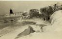
|---|---|
| Description: | Postcard view along icy shoreline of the pier and lighthouse on Lake Michigan at Port Washington in winter. |
If you didn't find the material you searched for, our Library Reference Staff can help.
Call our reference desk at 608-264-6535 or email us at: