 Search: LIGHTHOUSES
Filter: Reproduction Rights of For Sale
Filter: Subject of botany
Filter: Subject of water
Search: LIGHTHOUSES
Filter: Reproduction Rights of For Sale
Filter: Subject of botany
Filter: Subject of water
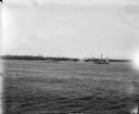
| Date: | 07 07 1898 |
|---|---|
| Description: | View across water of Sturgeon Bay. In the far distance are lighthouses, buildings, and barges along the shoreline. |

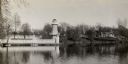
| Date: | |
|---|---|
| Description: | Michigan Island Lighthouse, Apostle Islands, Lake Superior. |
| Date: | 1950 |
|---|---|
| Description: | Lighthouse on Outer Island of the Apostle Islands. |
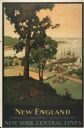
| Date: | 1947 |
|---|---|
| Description: | An original lithograph promoting New York Central Lines railway and the area of New England, deemed "America's Historic Summerland" in the poster. Featurin... |
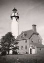
| Date: | 1960 |
|---|---|
| Description: | A view of the Eagle Harbor Lighthouse. |

| Date: | 1916 |
|---|---|
| Description: | This Wisconsin Conservation Commission map from 1916 shows Peninsula State Park in the Town of Gibraltar, Door County, Wisconsin. Depicted are open and pla... |
| Date: | |
|---|---|
| Description: | View of a U.S. lighthouse and Coast Guard station. |

| Date: | 1856 |
|---|---|
| Description: | View of Manitowoc from the north side. |

| Date: | 1916 |
|---|---|
| Description: | This version of a 1916 Wisconsin Conservation Commission map shows Peninsula State Park in the Town of Gibraltar, Door County, Wisconsin. Depicted are open... |

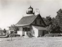
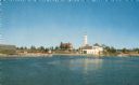
| Date: | 1915 |
|---|---|
| Description: | This map of Door County, Wisconsin, from the early 20th century shows roads, schools, churches, creameries and cheese factories, orchards, docks, quarries,... |
| Date: | 1915 |
|---|---|
| Description: | Colorized view of the Sherwood Point Lighthouse. Caption reads: "Sherwood Point Light House, Sturgeon Bay, Wis." |

| Date: | |
|---|---|
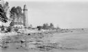
| Description: | A rocky coast is populated with homes, hotels, and a lighthouse. |
| Date: | 1935 |
|---|---|
| Description: | Lake Okauchee lighthouse. Buildings are in the background along a tree-covered shoreline. |
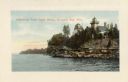
| Date: | 1920 |
|---|---|
| Description: | The Cana Island Lighthouse and keeper's house as seen across the rocky shoreline. |

| Date: | 1920 |
|---|---|
| Description: | View from beach across Spike Horn Bay towards Cana Island and the Cana Island Light. |

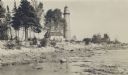
| Date: | 1909 |
|---|---|
| Description: | View across water towards the steep shoreline and lighthouse at Eagle Harbor. |

| Date: | 1960 |
|---|---|
| Description: | This mid-20th century tourist brochure for Bayfield County, Wisconsin, includes a map of the county showing towns, cities and villages, highways and roads,... |
| Date: | 1912 |
|---|---|
| Description: | The Cana Island lighthouse and keeper's house with the rocky shore in the foreground. |
| Date: | 1912 |
|---|---|
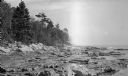
| Description: | Cana Island lighthouse is seen in the far distance across the stony shoreline along Lake Michigan. |

| Date: | 1967 |
|---|---|
| Description: | This tourist brochure for Bayfield County, Wisconsin, from 1967 includes a map of the county showing towns, cities and villages, highways and roads, railro... |
If you didn't find the material you searched for, our Library Reference Staff can help.
Call our reference desk at 608-264-6535 or email us at: