 Search: LIGHTHOUSES
Filter: County of Door
Search: LIGHTHOUSES
Filter: County of Door
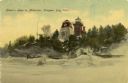
| Date: | 1908 |
|---|---|
| Description: | Hand-colored postcard view of Lover's Leap in Sturgeon Bay during winter. The view is from the frozen lake looking toward a lighthouse on shore. Caption re... |

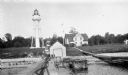
| Date: | 01 06 1958 |
|---|---|
| Description: | View from jetty out towards Lake Michigan entrance to Ship Canal. A large tank, streetlamp and buildings are on the left. On the opposite jetty is a lighth... |

| Date: | 1970 |
|---|---|
| Description: | This map shows roads, parks, swimming beaches, golf courses, yacht harbors, light houses, airports, public hunting grounds, waysides, schools, and fishing ... |
| Date: | 1927 |
|---|---|
| Description: | View of the Plum Island rear range lighthouse from the end of the pier. The brick house was home to the lighthouse keeper and the first and second assistan... |
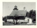
| Date: | 07 04 1947 |
|---|---|
| Description: | Group of people standing in the yard in front of the lighthouse. The verso has this annotation: "'Eagle Light' Lighthouse, Peninsula Park, Fish Creek, Wi... |

| Date: | 1900 |
|---|---|
| Description: | This blue line print map shows land use, cables, U.S.L.S.S. walk and clearing, and front and rear range lights on the Porte des Morts Passage. Tree types a... |

| Community: | Baileys Harbor |
|---|---|
| County: | Door |
| Historic Name: | BAILEYS HARBOR LIGHTHOUSE |
| Reference Number: | 42860 |

| Date: | 1906 |
|---|---|
| Description: | Hand-colored postcard view of the Sturgeon Bay ship canal from the bay toward shore. A sailboat is on the left and a lighthouse is on shore on the right. C... |
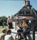
| Date: | 1969 |
|---|---|
| Description: | Three children and two adults are stand and sitting around an elderly man wearing a ship captains hat. He is holding a wooden model of a ship. The group of... |
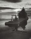
| Date: | 03 1969 |
|---|---|
| Description: | The Sturgeon Bay Ship Canal Pierhead Lighthouse silhouetted against the sun shining through the clouds. Snow covers the pier, and ice is floating on the la... |

| Date: | 1963 |
|---|---|
| Description: | Text on front reads: "Sherwood Point Lighthouse, Door County, Wisconsin." On reverse: "Sherwood Point Lighthouse is near Potawatomi State Park, north of St... |
| Location: | Pilot Island |
|---|---|
| Nearby City: | Death's Door Passage, Door County |
| Body of water: | Lake Michigan |
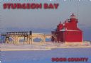
| Date: | 1963 |
|---|---|
| Description: | Text on front reads: "Sturgeon Bay, Door County." On reverse: "Sturgeon Bay, Wisconsin, Door County. North Pierhead Light. Winter shows its pretty face on ... |

| Date: | 1963 |
|---|---|
| Description: | Text on front reads: "Sherwood Point Lighthouse, Door County." On reverse: "Built in 1883, the Sherwood Point Lighthouse marks the entrance into Sturgeon B... |
| Location: | North of Potawatomi State Park |
|---|---|
| Nearby City: | West of Sturgeon Bay, Door County |
| Body of water: | Lake Michigan |

| Date: | 1950 |
|---|---|
| Description: | This map of Sturgeon Bay is part of the survey of the northern and northwestern lakes. The map shows lights, railroads, roads, and some public buildings. R... |

| Date: | 1941 |
|---|---|
| Description: | Elevated view of Sturgeon Bay in 1900. Sturgeon Bay Bridge spans the bay and several boats are on the water. A lighthouse sits on a small island in the bay... |
| Location: | Ridges Road |
|---|---|
| Nearby City: | Baileys Harbor, Door County |
| Body of water: | Lake Michigan |
| Location: | North Point Island |
|---|---|
| Nearby City: | Baileys Harbor, Door County |
| Body of water: | Lake Michigan |

| Date: | 04 1926 |
|---|---|
| Description: | This blueprint mostly shows various numbers within the canal and bay. Lake Michigan and Harobor of Refuge are shown along the far right side. Near the harb... |
If you didn't find the material you searched for, our Library Reference Staff can help.
Call our reference desk at 608-264-6535 or email us at: