 Search: LIGHTHOUSES
Filter: County of Door
Filter: Subject of water
Search: LIGHTHOUSES
Filter: County of Door
Filter: Subject of water
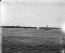
| Date: | 07 07 1898 |
|---|---|
| Description: | View across water of Sturgeon Bay. In the far distance are lighthouses, buildings, and barges along the shoreline. |
| Date: | 1960 |
|---|---|
| Description: | A view of the Eagle Harbor Lighthouse. |

| Date: | 1916 |
|---|---|
| Description: | This Wisconsin Conservation Commission map from 1916 shows Peninsula State Park in the Town of Gibraltar, Door County, Wisconsin. Depicted are open and pla... |
| Date: | |
|---|---|
| Description: | View of a U.S. lighthouse and Coast Guard station. |

| Date: | 1916 |
|---|---|
| Description: | This version of a 1916 Wisconsin Conservation Commission map shows Peninsula State Park in the Town of Gibraltar, Door County, Wisconsin. Depicted are open... |

| Date: | 1915 |
|---|---|
| Description: | This map of Door County, Wisconsin, from the early 20th century shows roads, schools, churches, creameries and cheese factories, orchards, docks, quarries,... |
| Date: | 1915 |
|---|---|
| Description: | Colorized view of the Sherwood Point Lighthouse. Caption reads: "Sherwood Point Light House, Sturgeon Bay, Wis." |

| Date: | 1915 |
|---|---|
| Description: | View of the Sturgeon Bay ship canal. Caption reads: "Sturgeon Bay Ship Canal." |

| Date: | 1913 |
|---|---|
| Description: | View of the canal. Caption reads: "The Canal, Stugeon[sic] Bay, Wis." |
| Date: | 1920 |
|---|---|
| Description: | The Cana Island Lighthouse and keeper's house as seen across the rocky shoreline. |

| Date: | 1920 |
|---|---|
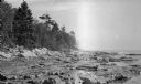
| Description: | View from beach across Spike Horn Bay towards Cana Island and the Cana Island Light. |

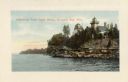
| Date: | 1909 |
|---|---|
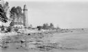
| Description: | View across water towards the steep shoreline and lighthouse at Eagle Harbor. |
| Date: | 1912 |
|---|---|
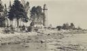
| Description: | The Cana Island lighthouse and keeper's house with the rocky shore in the foreground. |
| Date: | 1912 |
|---|---|
| Description: | Cana Island lighthouse is seen in the far distance across the stony shoreline along Lake Michigan. |
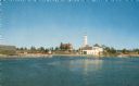
| Date: | 1959 |
|---|---|
| Description: | Text on reverse reads: "Coast Guard Station and Light House at Sturgeon Bay Ship Canal, Door County, Wisconsin." The lighthouse was completed in 1898 but s... |
| Date: | 1957 |
|---|---|
| Description: | Color photographic postcard view of the Eagle Lighthouse in Peninsula State Park. |

| Date: | 1953 |
|---|---|
| Description: | View across water towards the Sturgeon Bay Canal Lighthouse, with a group of people in a motorboat in the foreground. |

| Date: | 1966 |
|---|---|
| Description: | A colored map depiction of Door County, Wisconsin, with pictorial highlights, titled: "Door County — Wisconsin's Air Conditioned Peninsula Playground." |

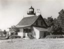
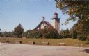
| Date: | 03 30 1953 |
|---|---|
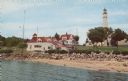
| Description: | External view of the Eagle Bluff Lighthouse (also called the Eagle Bluff Light), which is located in Peninsula State Park near Ephraim. |

| Date: | 1907 |
|---|---|
| Description: | The Ruins of the old Light House on Plum Island near Sturgeon Bay. Caption at bottom reads: "Ruins of Old Light House on Plum Island," "Made expressly for ... |
If you didn't find the material you searched for, our Library Reference Staff can help.
Call our reference desk at 608-264-6535 or email us at: