 Search: Increase
Search: Lapham
Search: papers
Filter: Categories of Wisconsin Historical Images
Filter: Creator Name of Lapham, Increase Allen
Filter: County of Milwaukee
Search: Increase
Search: Lapham
Search: papers
Filter: Categories of Wisconsin Historical Images
Filter: Creator Name of Lapham, Increase Allen
Filter: County of Milwaukee

| Date: | 1836 |
|---|---|
| Description: | Pencil on tracing paper. Rough sketch of Milwaukee. Left top corner reads: "From Map of northern part of Illinois and the surveyed part of Wisconsin Territ... |
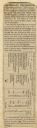
| Date: | 07 22 1837 |
|---|---|
| Description: | Table printed in Milwaukee Advertiser indicating the time of flowering of several wild plants at Milwaukee and near the head of the Pishtaka River. |

| Date: | 1854 |
|---|---|
| Description: | Reproduction printed on glossy, cloth-backed paper. Right side includes "References," or points of interest that correspond to numbers on the map. Running ... |

| Date: | 1844 |
|---|---|
| Description: | An ink on paper, hand-drawn map of Milwaukee County that shows the sectioning of townships, the boundary of the canal grant, roads, streams, lakes, includi... |

| Date: | 1830 |
|---|---|
| Description: | An ink on paper, hand-drawn map of the town of Milwaukee, showing the divisions and landownership within the town by private individuals as well as those l... |

| Date: | 1837 |
|---|---|
| Description: | A pen and ink on tracing paper, hand-drawn and colored map the proposed route of the Milwaukee and Rock River Canal, ranging from the Rock River in the wes... |
If you didn't find the material you searched for, our Library Reference Staff can help.
Call our reference desk at 608-264-6535 or email us at: