 Search: Increase
Search: A.
Search: Lapham
Filter: Categories of Wisconsin Historical Images
Filter: County of Dane
Search: Increase
Search: A.
Search: Lapham
Filter: Categories of Wisconsin Historical Images
Filter: County of Dane
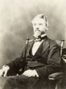
| Date: | |
|---|---|
| Description: | Formal portrait of Increase Lapham sitting in a chair. |

| Date: | 1867 |
|---|---|
| Description: | This 1867 manuscript map by Increase Lapham shows the topography and geology of the Blue Mounds region in the Town of Brigham in Iowa County and the towns ... |
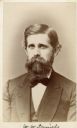
| Date: | 1872 |
|---|---|
| Description: | Carte-de-visite portrait of Professor W.W. Daniels, University of Wisconsin geologist. Daniels worked as one of Increase Lapham's assistants during the Wis... |
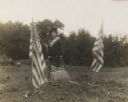
| Date: | 10 07 1914 |
|---|---|
| Description: | Sara (Mrs. Joseph) Mallon (Menominee) of Milwaukee, wearing a sash stands between two American flags behind a memorial that reads, "Indian Mounds: One of s... |
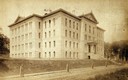
| Date: | 1880 |
|---|---|
| Description: | View across Park Street of Science Hall at the base of Bascom Hill on the University of Wisconsin Madison campus. |
If you didn't find the material you searched for, our Library Reference Staff can help.
Call our reference desk at 608-264-6535 or email us at: