 Search: Increase
Search: A.
Search: Lapham
Search: papers
Filter: Categories of Wisconsin Historical Images
Filter: Year of 1800-1899
Filter: Year of 1830-1839
Search: Increase
Search: A.
Search: Lapham
Search: papers
Filter: Categories of Wisconsin Historical Images
Filter: Year of 1800-1899
Filter: Year of 1830-1839
| Date: | 1835 |
|---|---|
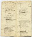
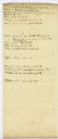
| Description: | Page from Increase Lapham's 1935 botanical diary in which he listed plants he observed in flower stage. |
| Date: | 1838 |
|---|---|
| Description: | Page from Increase Lapham's 1838 botanical diary in which he listed plants he observed in flower stage. |
| Date: | 02 15 1830 |
|---|---|
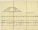
| Description: | Increase Lapham's drawing of a railroad tunnel and railroad tracks. |

| Date: | 12 22 1830 |
|---|---|
| Description: | Increase Lapham's drawing of the geological profile between the Sandusky plains and Portsmouth, Ohio. |
| Date: | 1838 |
|---|---|
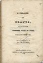
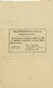
| Description: | Title page of Increase Lapham's Catalog of Plants Found in the vicinity of Milwaukee, Wisconsin Territory. |
| Date: | 1832 |
|---|---|
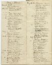
| Description: | Page from the handwritten index to Lapham's Notes and accounts of canals, particularly the Ohio Canal near Portsmouth, 1830-1832. |

| Date: | 1833 |
|---|---|
| Description: | Increase Lapham's plan for the canal terminus on Portsmouth Point at the confluence of the Scioto and Ohio Rivers. |
| Date: | 02 1831 |
|---|---|
| Description: | Printed invitation addressed to Mr. I.A. Lapham for a ball at C. McCoy's hotel to be held on February 17, 1831. |

| Date: | 1837 |
|---|---|
| Description: | Copy of N.F. Hyer's original map of Aztalan as published in the Milwaukee Advertiser, February 25, 1837. |
| Date: | 07 22 1837 |
|---|---|
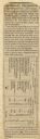
| Description: | Table printed in Milwaukee Advertiser indicating the time of flowering of several wild plants at Milwaukee and near the head of the Pishtaka River. |

| Date: | 1837 |
|---|---|
| Description: | A pen and ink on tracing paper, hand-drawn and colored map the proposed route of the Milwaukee and Rock River Canal, ranging from the Rock River in the wes... |
If you didn't find the material you searched for, our Library Reference Staff can help.
Call our reference desk at 608-264-6535 or email us at:
