 Search: Increase
Search: A.
Search: Lapham
Search: papers
Filter: Categories of Wisconsin Historical Images
Filter: Creator Name of Lapham, Increase Allen
Filter: Subject of geology
Search: Increase
Search: A.
Search: Lapham
Search: papers
Filter: Categories of Wisconsin Historical Images
Filter: Creator Name of Lapham, Increase Allen
Filter: Subject of geology
| Date: | 1870 |
|---|---|
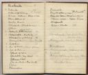
| Description: | Page from a diary kept by Increase Lapham in California between April 11 and May 19, 1870. The page shows a portion of a list of minerals of California. |

| Date: | 1828 |
|---|---|
| Description: | Drawing by Increase Lapham showing the geological profile of the land between Utica and Knob Creek, Kentucky at a scale of 1/2 inch to a mile. |
| Date: | 06 28 1850 |
|---|---|
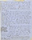
| Description: | Letter from Increase Lapham to his wife, Ann Maria Alcott, in Milwaukee. Lapham was at Aztalan and wrote to Anna regarding the geology of the region. He in... |

| Date: | 12 22 1830 |
|---|---|
| Description: | Increase Lapham's drawing of the geological profile between the Sandusky plains and Portsmouth, Ohio. |

| Date: | 1828 |
|---|---|
| Description: | Increase Lapham's drawing and description of an earth borer for his handwritten manuscript, Notes and Accounts of Canals, Particularly the Ohio Canal Ne... |

| Date: | 1864 |
|---|---|
| Description: | This map is pen and pencil on paper and shows a profile of the Blue Mound and East Blue Mound. |

| Date: | 1864 |
|---|---|
| Description: | This map is pen and pencil on paper and shows a profile of the Blue Mound and East Blue Mound. |

| Date: | 1864 |
|---|---|
| Description: | This map is pen and watercolor on paper and shows a profile and the geological formation of Blue Mound. Also shown is the location of Arnold's Hotel and Br... |

| Date: | 1864 |
|---|---|
| Description: | This map is pen and watercolor on paper and shows a profile and geological sections of the Apple River, Little Otter Creek, Woods' Branch, Bonners' Branch,... |

| Date: | 1864 |
|---|---|
| Description: | This map is pen and watercolor on paper and shows a profile and geological sections of the Blue Mounds, Hollow Run, Bogies Hollow Run, Bear Creek, East Bre... |

| Date: | 1864 |
|---|---|
| Description: | This map is pen and watercolor on paper and shows a profile and geological sections of the Spensley Break, James Break, Wisconsin River, and Little Bear Cr... |

| Date: | 1864 |
|---|---|
| Description: | This map is pen and watercolor on paper and shows a profile and geological sections of the East Blue Mound Break, Blue Mound Creek, Black Earth River, and ... |
If you didn't find the material you searched for, our Library Reference Staff can help.
Call our reference desk at 608-264-6535 or email us at: