 Search: Harry
Search: Elsworth
Search: Cole
Filter: Subject of trees
Search: Harry
Search: Elsworth
Search: Cole
Filter: Subject of trees
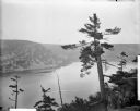
| Date: | 1910 |
|---|---|
| Description: | Elevated view across Devil's Lake from the West Bluff. Railroad tracks are seen along the base of the East Bluff. |

| Date: | 1906 |
|---|---|
| Description: | W.H. Canfield stands in front of a log cabin. There is a brick chimney on the right side of the building. |
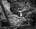
| Date: | 1909 |
|---|---|
| Description: | Two women wearing long dresses pose on a large boulder at the base of a rock formation in a shady glen. |
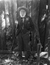
| Date: | 1906 |
|---|---|
| Description: | William H. Canfield, an early settler of Sauk County, civil engineer, local historian and archeologist, posing outdoors holding a walking stick. |
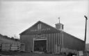
| Date: | 1926 |
|---|---|
| Description: | A barn with a large cupola, built in 1852, on "The Capt. W.P. Ruggles Estate." |
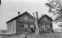
| Date: | 1925 |
|---|---|
| Description: | A deteriorating wooden structure with two gables on the front, identified as the Red Tavern between Kilbourn and Mauston, built in 1848. |
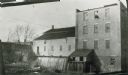
| Date: | 04 1926 |
|---|---|
| Description: | Old stone mill, with a smaller wooden addition on the left. Water is passing through the flume. |
| Date: | 1923 |
|---|---|
| Description: | Wilson's Tavern, north of the point where the road from Black Hawk enters Trunk Highway 60. Built by John Wilson on Wilson Creek. |
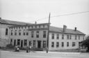
| Date: | 1925 |
|---|---|
| Description: | Three men are working outside on the street in front of the Dodgeville Hotel. |
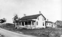
| Date: | 1909 |
|---|---|
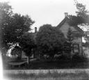
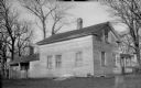
| Description: | E.D. King residence, once a post office, at King's Corners. A wooden walkway with a ramp at the roadside extends from the front door. |
| Date: | 1909 |
|---|---|
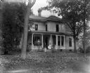
| Description: | Exterior view of the Monroe (Munroe?) House, with three people posing on the front porch. |

| Date: | 1909 |
|---|---|
| Description: | Exterior view of a hop house built in about 1868 by H.J. Meyer. |
| Date: | 1910 |
|---|---|
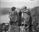
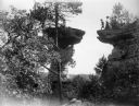
| Description: | Elevated view of a woman standing in the Devil's Doorway above Devil's Lake. There is graffiti on the rocks. |
| Date: | 1910 |
|---|---|
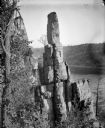
| Description: | Elevated view of Cleopatra's Needle with Devil's Lake in the background. |
| Date: | 1910 |
|---|---|
| Description: | A winter view of Chimney Rock at the Dells. There is snow on the ground and ice on the river. |
| Date: | 1910 |
|---|---|
| Description: | A man in motion moves toward making the leap to Stand Rock as men and women watch nearby. |

| Date: | 1909 |
|---|---|
| Description: | View of Skillet Falls from downstream. The trees are bare, and tree stumps are visible on the hill in the background, known locally as Mount Baldy. |
| Date: | 1924 |
|---|---|
| Description: | View of the Low Tavern from the yard. There are two small porches on the left and right side of the building, and two chimneys. |

| Date: | 1924 |
|---|---|
| Description: | The inactive Leland mill, with the faded painted sign, "Leland Roller Mill," on the upper story. |

| Date: | 1925 |
|---|---|
| Description: | View from yard of small cottage standing on the northwest shore of Lake Mendota on the site of Rowan, also known as the St. Cyr stopping place. |
If you didn't find the material you searched for, our Library Reference Staff can help.
Call our reference desk at 608-264-6535 or email us at: