Search: Harry
Search: Elsworth
Search: Cole
Filter: County of Columbia
Search: Harry
Search: Elsworth
Search: Cole
Filter: County of Columbia
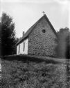
| Date: | 1909 |
|---|---|
| Description: | Stone chapel on a hillside at Durwards Glen. |
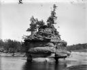
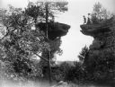
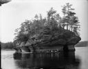
| Date: | 1910 |
|---|---|
| Description: | The rock formation at the Dells known as the Sugar Bowl. |
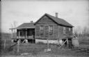
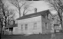
| Date: | 1924 |
|---|---|
| Description: | The old toll house. The house is surrounded by a sagging wire fence, and there are two pumps in the overgrown yard. |
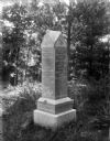
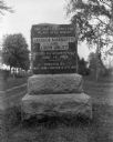
| Date: | 1910 |
|---|---|
| Description: | The Staudenmayer grave marker set amid the lush vegetation of Durwards Glen. |
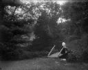
| Date: | 1909 |
|---|---|
| Description: | Woman standing on footbridge in a forested area in Durwards Glen. |
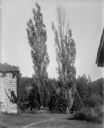
| Date: | 1909 |
|---|---|
| Description: | View of two Lombardy poplar trees next to a stone building. |
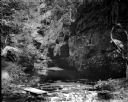
| Date: | 1909 |
|---|---|
| Description: | A view of the "Glen of the Calydon" showing a stream and rock formations. |
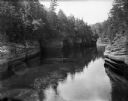
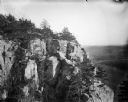
| Date: | 1910 |
|---|---|
| Description: | A view of the rock formations along the Wisconsin River at the Dells. |

| Date: | 1907 |
|---|---|
| Description: | A barren area of sandy soil and rocks identified as the site of an Indian village near Okee. |
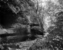
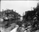
| Date: | 1910 |
|---|---|
| Description: | A view of a ravine showing rock strata and a stream. |
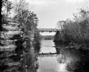
| Date: | 1909 |
|---|---|
| Description: | View from river of Dell Creek bridge with bluff and birch trees on the left. |
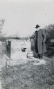
| Date: | 10 1924 |
|---|---|
| Description: | J.R. Hastie stands beside a chain and crank operated pump at the pioneer well, "a few miles below Portage." |
| Date: | 1910 |
|---|---|
| Description: | View of the face of the bluff at Gibraltar Rock, with farmland and other bluffs far below in the distance. |
| Date: | 1908 |
|---|---|
| Description: | A view of the Marquette-Joliet historical marker. Erected by the Wau-bun Chapter of the Daughters of the American Revolution. |
| Date: | 1923 |
|---|---|
| Description: | Wilson's Tavern, north of the point where the road from Black Hawk enters Trunk Highway 60. Built by John Wilson on Wilson Creek. |
| Date: | 1910 |
|---|---|
| Description: | A man in motion moves toward making the leap to Stand Rock as men and women watch nearby. |
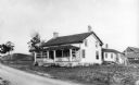
| Date: | 1924 |
|---|---|
| Description: | View of the Low Tavern from the yard. There are two small porches on the left and right side of the building, and two chimneys. |
| Date: | 1910 |
|---|---|
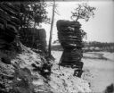
| Description: | View from bank of the Wisconsin River of the Jaws of the Dells in winter. Snow is on the ground and ice lines the shoreline. |
| Date: | 1910 |
|---|---|
| Description: | View across Wisconsin River of men and women in canoes at the base of Lone Rock at the Dells. |
If you didn't find the material you searched for, our Library Reference Staff can help.
Call our reference desk at 608-264-6535 or email us at: